Every country offers a good number of hiking treks. Depending on the terrain, they can be easy walks or extreme challenges requiring much preparation and effort.
- Easy Hikes
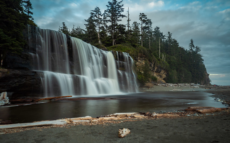
- 1. Route K, Plitvice Lakes National Park
- 2. El Caminito del Rey
- 3. Rakiura Track
- 4. The Great Ocean Walk
- Moderate Difficulty Hikes
- 5. Great Wall of China, Jinshanling Section
- 6. The Inca Trail
- 7. Milford Track
- 8. Ocean to Lake Trail, Florida
- 9. The Torres del Paine “W” Circuit
- 10. The Lycian Way, Turkey
- 11. Sinai Trail
- 12. Camino Primitivo, Camino de Santiago
- Moderate to Hard Hikes
- 13. La Ciudad Perdida – The Lost City Trek
- 14. Mount Kilimanjaro Trek (Machame Route)
- 15. Tour du Mont Blanc
- Hard Hikes
- 16. The Long Range Traverse
- 17. Backbone Trail
- 18. Everest Base Camp Trek
- 19. The Annapurna Circuit Trek
- 20. The John Muir Trail via Yosemite Valley
- 21. The Jordan Trail
- Very Hard Hikes
- 22. The Fish River Canyon
- 23. Kungsleden (The King’s Trail)
- 24. The Great Divide Trail
- 25. Pacific Crest Trail
- Extremely Hard Hikes
- 26. Dientes Circuit Trek
- 27. The West Coast Trail
- 28. Dolomite High Route (Alta Via Uno)
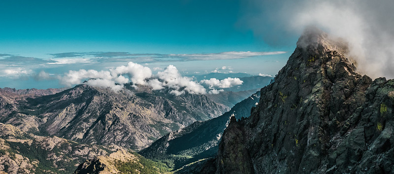
- 29. GR20
- 30. Snowman Trek
- Read more
The ultimate goal for taking a hike can also be different: spiritual search, challenging the body, or relaxing the brain. This list ranks 30 bucket list hikes by difficulty level: from the easiest to the hardest, taking into account the duration as well.
Easy Hikes
1. Route K, Plitvice Lakes National Park
Route K in Plitvice Lakes National Park is a loop trail that takes you through one of Croatia’s most stunning natural landscapes. This hike offers views of the park’s famous cascading lakes and waterfalls. The trail is well-marked and maintained, making it accessible for hikers of all levels.

Veliki Slap comes early and makes an impression without demanding your attention for long, since the trail keeps moving and pulls you forward.
Jezero Kozjak feels like a midpoint breather, wide and calm, where the pace slows almost on its own. The contrast between the Upper and Lower Lakes becomes clear as you walk, with tighter canyon walls below and more open, layered scenery above.
Trek Details
The wooden walkways and bridges keep you close to the water, sometimes close enough to notice small details like ripples and fish instead of focusing on the bigger view. Forest sections break things up, adding shade and quiet stretches where footsteps replace the sound of waterfalls
2. El Caminito del Rey
El Caminito del Rey, often referred to as the “King’s Little Pathway,” is a thrilling walkway pinned along the steep walls of a narrow gorge in El Chorro, near Málaga. Known for the dramatic views and heights, the path has been renovated and is now safer for hikers, though it still is an adrenaline-pumping experience.

The path cuts through the Gaitanes Gorge, with sheer rock walls rising close enough that the scale feels immediate rather than distant.
Trek Details
Below, the Guadalhorce River stays in view for much of the walk, quietly grounding the experience as the trail clings to the cliffside. The hanging bridge adds a brief moment of focus as you cross, then fades into the background once you start looking outward again.
3. Rakiura Track
The Rakiura Track on Stewart Island is one of New Zealand’s Great Walks. This loop trail takes you through lush rainforest, along beautiful coastlines, and across rugged terrain. It’s a relatively gentle hike, making it accessible for most fitness levels.

The Rakiura Track starts quietly at Lee Bay, where the trail immediately settles into its own pace without any sense of buildup. Maori Beach comes soon after, open and exposed, with sand underfoot and the sea setting the mood early.
Trek Details
From Maori Beach, the walk shifts inland toward Port William Hut, moving through thick native bush where ferns crowd the path and light filters in uneven patches.
North Arm Hut comes later, sitting right by Paterson Inlet, where the water changes constantly and the day tends to slow down. Birdlife is everywhere if you stay aware, and spotting a kiwi around dusk feels quietly special.
4. The Great Ocean Walk
The Great Ocean Walk stretches along the southern coast of Victoria, offering hikers spectacular coastal views, pristine beaches, and diverse ecosystems. This long-distance walk takes you through national parks, along rugged coastlines, and past historic shipwrecks.
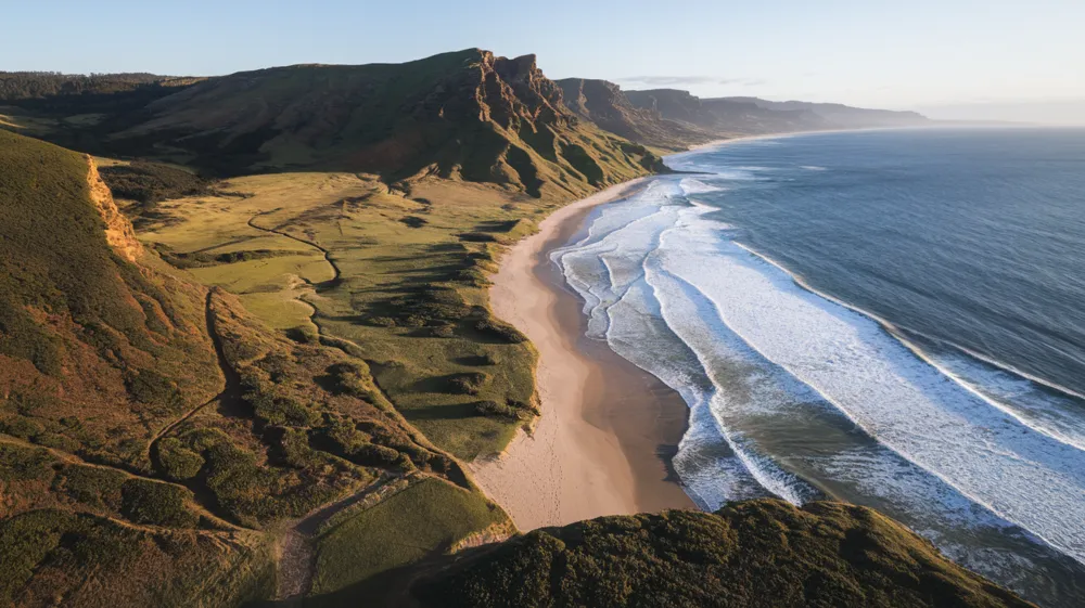
The Twelve Apostles show up as massive limestone stacks rising straight out of the water, and seeing them after hours of walking gives them a different weight than a quick roadside stop. Gibson Steps brings you down to sea level, where the cliffs feel taller and the scale of the coast finally clicks.
Trek Details
Further along, the Cape Otway Lightstation stands as a quiet marker of how exposed this stretch of coastline really is. Loch Ard Gorge carries its own sense of history, shaped by shipwreck stories and enclosed by steep rock walls.
Moderate Difficulty Hikes
5. Great Wall of China, Jinshanling Section
The Jinshanling section of the Great Wall of China is renowned for its stunning scenery and well-preserved watchtowers. This moderately challenging hike offers a mix of restored and original segments of the wall.
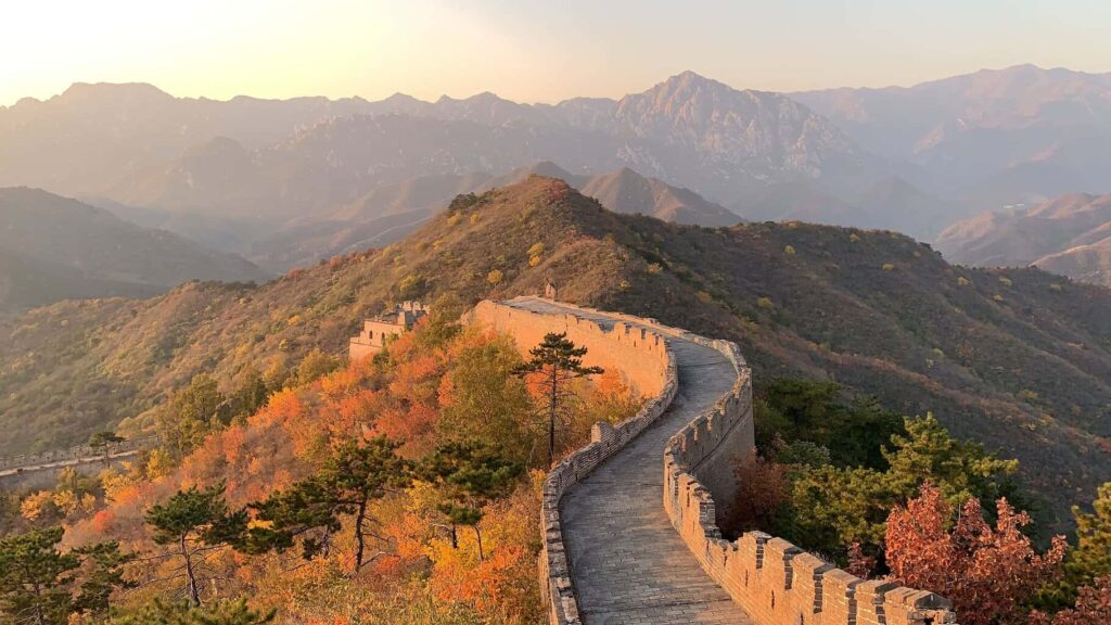
Much of what you walk today dates back to the Ming Dynasty, when this section was rebuilt in the 16th century as part of a broader defensive network.
Trek Details
The wall here includes more than 60 watchtowers, many positioned to maintain clear lines of sight with one another, which becomes obvious as you hike and see how carefully the route follows the terrain.
The elevation changes are constant, and certain climbs are steep enough to turn short distances into deliberate efforts. Jinshanling is often linked with the Simatai section for longer hikes, and its relative distance from central Beijing helps keep foot traffic lighter, especially early in the day
6. The Inca Trail
The Inca Trail is one of the most iconic hikes in the world, leading adventurers through the Andes to the ancient citadel of Machu Picchu. The trail passes through diverse landscapes, including cloud forests, alpine tundra, and Incan ruins, providing a rich cultural and historical experience.
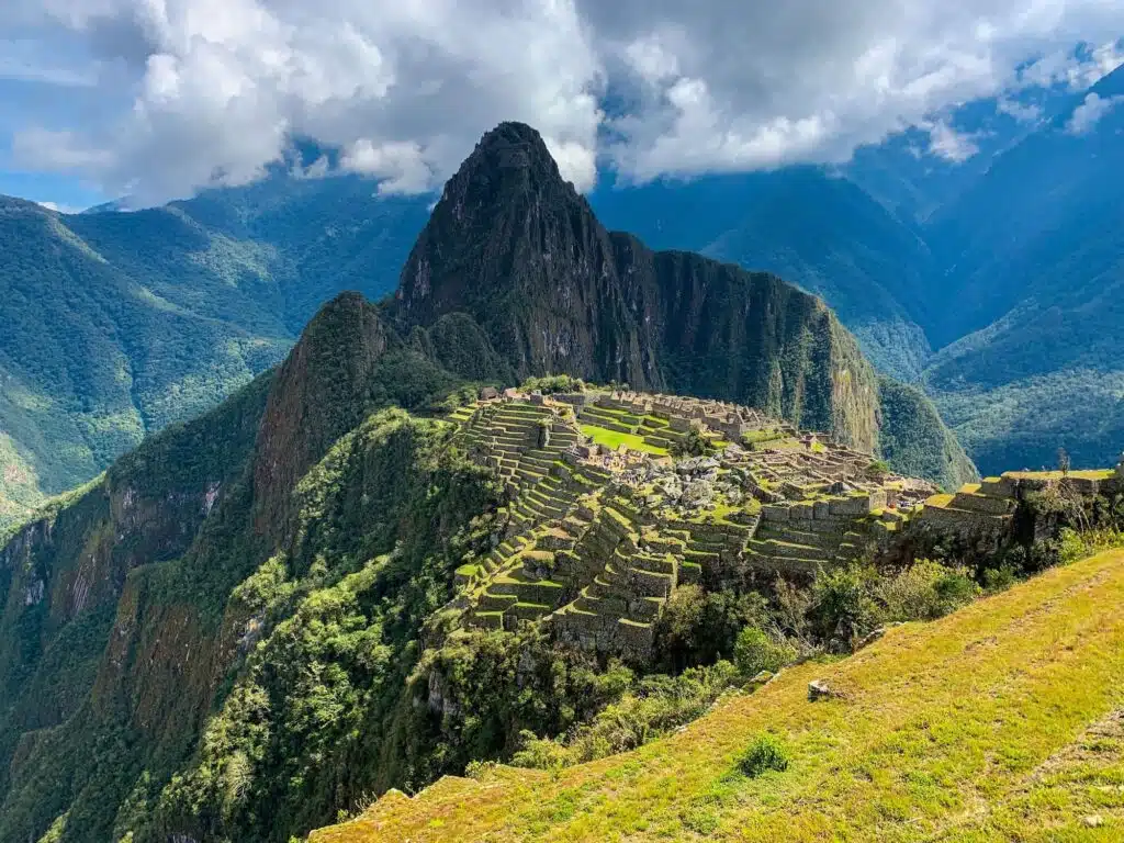
The Inca Trail builds toward Machu Picchu in a way that feels deliberate, with each section adding context to the one that follows. Dead Woman’s Pass, or Warmiwañusca, marks the highest point of the trail at just over 4,200 meters and sets the physical tone early on, with long stone staircases and thin air shaping the climb.
Once past the pass, the route begins to shift, mixing stretches of forest with stone paths that hint at what lies ahead. Ruins appear regularly along the trail, starting with Llactapata, which offers early insight into how the Incas placed settlements in relation to the surrounding valleys.
Trek Details
Wiñay Wayna comes later and stands out for its size, with agricultural terraces stepping down the hillside and water channels still cutting clean lines through the stone. Phuyupatamarca sits high above the clouds, often cool and misty, and shows the precision of Inca engineering through its fountains and finely fitted walls.
7. Milford Track
The Milford Track is one of New Zealand’s Great Walks, renowned for its stunning landscapes, including lush rainforests, alpine passes, and cascading waterfalls. This moderately challenging hike provides an immersive experience in Fiordland National Park.
The Milford Track unfolds at a steady pace, starting in the wide, flat floor of the Clinton Valley, where the surrounding peaks feel close without being overwhelming. The valley eases you into the walk, with river views and long forest stretches that make the early days feel more about settling in than pushing hard.
The climb over Mackinnon Pass changes that rhythm, bringing steeper terrain and a sense of exposure as the track rises above the tree line. On the descent, Sutherland Falls comes into view, dropping nearly 580 meters and reminding you how much water shapes this landscape.
Trek Details
The Arthur Valley follows, narrower and more enclosed, with rain, moss, and rock creating a quieter, more concentrated atmosphere. The track finishes at Milford Sound, where the mountains fall straight into the water, and the scale of Fiordland finally makes sense after days spent walking through it.
8. Ocean to Lake Trail, Florida
The Ocean to Lake Trail is a unique hike through a variety of ecosystems in southern Florida. This trail takes hikers from the Atlantic coast all the way to the shores of Lake Okeechobee. The trek starts right at Hobe Sound Beach, where sand and salt air make it hard to believe you are about to walk inland across an entire state ecosystem.
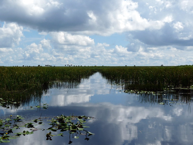
Then it quickly leaves the coast and enters Jonathan Dickinson State Park, where the landscape shifts into pine flatwoods, cypress swamps, and open wetlands that feel unmistakably Floridian.
Boardwalks and sandy paths carry you through low, wet areas where water levels change with the seasons and shape the walk day by day.
Trek Details
The route follows stretches of the Loxahatchee River, one of Florida’s designated Wild and Scenic Rivers, adding slow-moving water and shaded banks to the experience. As the trail continues north, the land opens up again on the approach to Lake Okeechobee, where the horizon flattens and the scale changes completely.
Wildlife is part of the everyday scenery here, with alligators resting near the water, wading birds moving through marshes, and seasonal wildflowers lining the trail, making the walk feel grounded in place rather than built around a single highlight.
9. The Torres del Paine “W” Circuit
The Torres del Paine “W” Circuit is one of the most famous treks in Patagonia, known for its breathtaking landscapes, including towering granite peaks, turquoise lakes, and expansive glaciers. This moderately challenging hike offers a diverse range of scenery and wildlife.
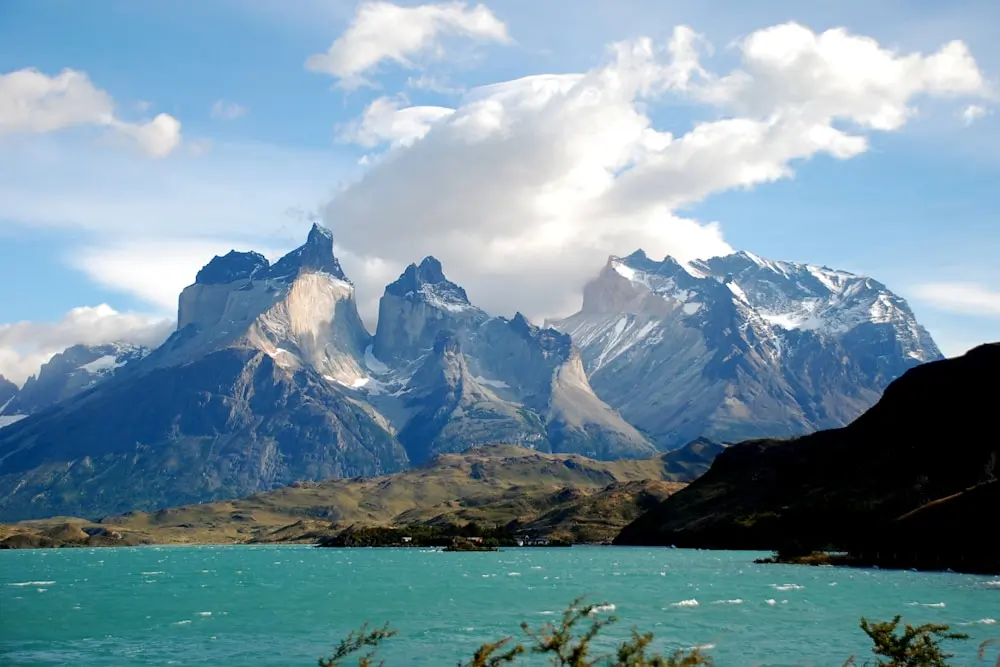
The approach to the Towers of Paine, known locally as Las Torres, is often the most talked about section, with a steady climb that ends at a glacial lake beneath the granite spires. On the western end of the route, Grey Glacier stretches out in slow motion, its fractured surface shifting color with the light and weather.
The French Valley cuts deep into the heart of the range, where hanging glaciers and rock walls make the scale of the park hard to ignore. Lake Nordenskjöld connects several parts of the circuit, its wind driven waves and changing color acting as a constant reference point.
Trek Details
The Cuernos del Paine (Horns of Paine) stand out for their layered rock formations, visible from multiple angles along the trail. Wildlife appears regularly along the route, with guanacos moving across open ground, foxes keeping their distance, and condors circling high above, tying the whole walk to the wider Patagonian landscape.
10. The Lycian Way, Turkey
The Lycian Way is a long-distance trail that winds along the coast of ancient Lycia, offering hikers a mix of stunning coastal views, mountainous terrain, and historical ruins. This trail is moderately challenging due to its length and diverse terrain.

The Lycian Way starts strong at the Ölüdeniz Lagoon, where clear water and steep hills set the tone before the trail heads into quieter territory. The descent toward Butterfly Valley feels sudden, dropping you into a narrow canyon where cliffs close in and the sea feels tucked away instead of wide open.
Ancient history becomes part of the daily walk as the route passes through the ruins of Patara, Xanthos, and Myra, places where broken columns and old theaters sit right alongside footpaths and farmland. Farther along the coast, the lighthouse at Cape Gelidonya marks one of the most remote-feeling sections of the trail, with open sea views and long, exposed stretches that reward an early start.
Trek Details
The trail regularly dips into towns like Kaş and Kalkan, where cafes, harbors, and quiet streets make a natural pause before heading back into the hills. Inland sections near Mount Olympos add another layer, especially around the Chimera flames, where natural gas fires burn straight from the rock after dark, closing out the walk with something that feels both ancient and strangely ordinary at the same time.
11. Sinai Trail
The Sinai Trail is Egypt’s first long-distance hiking trail, traversing the deserts of the Sinai Peninsula. This trail takes hikers through rugged mountains, sweeping deserts, and ancient historical sites. It’s also the best way to experience the canyons.

Many routes pass near St. Catherine’s Monastery, where stone walls sit quietly beneath towering peaks, and the sense of time feels compressed. Climbs around Mount Sinai bring long views across bare ridgelines, with walking paths that have been used for centuries by pilgrims and traders.
The trail also moves through places like Wadi Feiran, where palms, water, and cultivated land feel almost unexpected after days of rock and dust. Gebel Serbal rises nearby, adding a more rugged and remote feel to this part of the walk. Bedouin villages appear along different sections, grounding the journey in everyday routines rather than landmarks alone.
Trek Details
One of the defining features of the Sinai Trail is its flexibility, with several possible endpoints that depend on the chosen route, reinforcing the idea that this is a network of paths shaped by people and place, not a fixed beginning and finish.
12. Camino Primitivo, Camino de Santiago
The Camino Primitivo is the oldest route of the Camino de Santiago, known for its challenging terrain and scenic beauty. This historic pilgrimage path takes hikers through lush forests, rolling hills, and quaint villages, offering a serene and reflective journey.
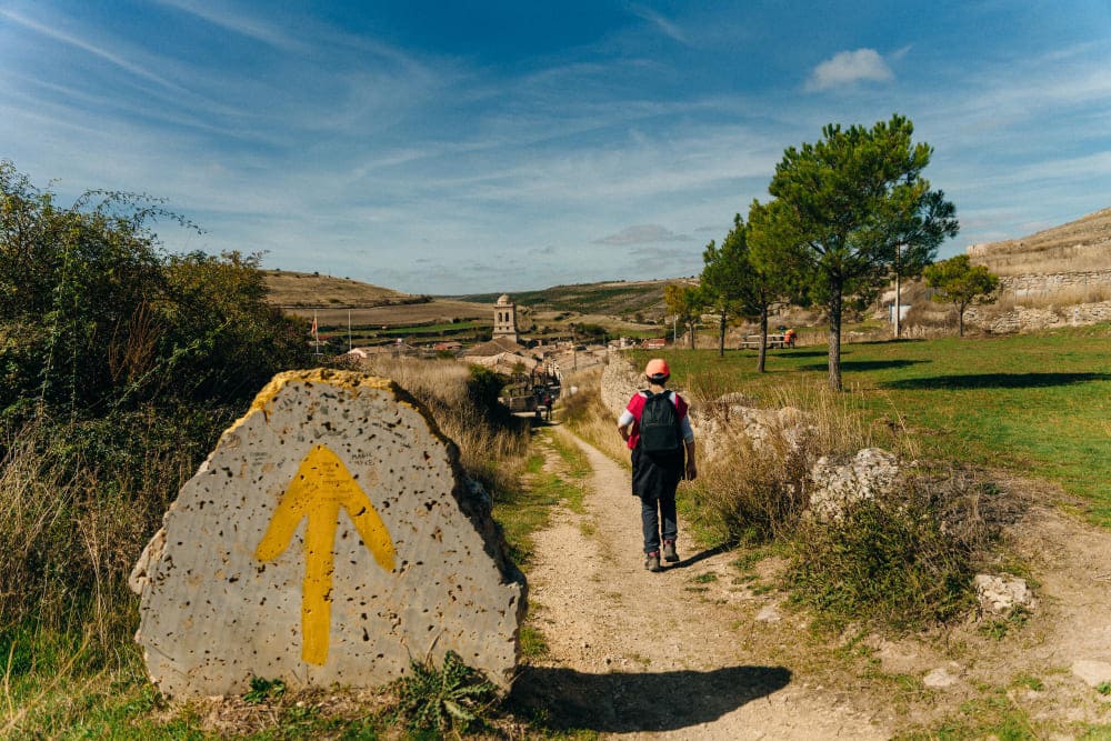
The Camino Primitivo begins at Oviedo Cathedral, setting off on a route that feels personal from the first steps. The path moves quickly into quieter territory, climbing into the mountains and passing through small villages where daily life carries on without much attention to pilgrims.
Reaching Lugo Roman Walls adds a clear sense of history, with the trail circling the city along fortifications that have stood for nearly two thousand years. Beyond Lugo, the landscape softens into rolling farmland, forest paths, and open stretches of Galician countryside that stay green even in dry months.
Trek Details
The walking feels steady and grounded, shaped by elevation changes and long distances between towns. Arriving at Santiago de Compostela Cathedral carries extra weight after such a demanding route, closing the journey in a way that feels earned through effort and quiet miles rather than crowds or ceremony.
Moderate to Hard Hikes
13. La Ciudad Perdida – The Lost City Trek
The Lost City Trek is a challenging hike through the dense jungle of the Sierra Nevada de Santa Marta. This trek leads to the ancient city of Teyuna, also known as La Ciudad Perdida, which predates Machu Picchu. The journey involves river crossings, steep climbs, and descents through tropical rainforests.
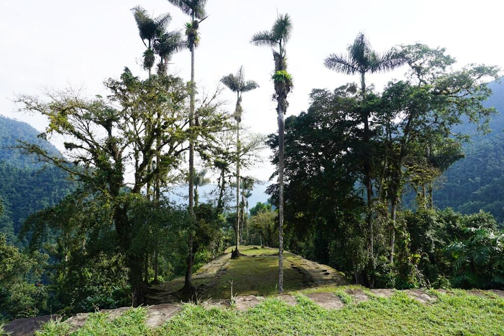
The Lost City Trek takes a few days to settle into, mostly because the environment keeps asking for your attention. The ancient terraces and stone structures of La Ciudad Perdida sit high in the Sierra Nevada, reached by long staircases that make it clear this place was never meant to be easy to access.
Along the way, the trail passes through Indigenous villages belonging to the Kogi and Wiwa people, where daily life continues quietly alongside passing hikers. The jungle is thick and ever-present, with humidity, dense vegetation, and constant sound shaping each day on the trail. Wildlife shows up when you least expect it, with monkeys moving through the canopy and flashes of birds cutting across the path.
Trek Details
River crossings and waterfalls are part of the routine rather than obstacles, often marking natural breaks in the day where walking slows and resets. By the time you reach the terraces at the top, the climb and the setting explain why this route feels more like a journey through a living landscape than a hike built around a single destination.
14. Mount Kilimanjaro Trek (Machame Route)
The Machame Route, also known as the “Whiskey Route,” is one of the most popular paths to the summit of Mount Kilimanjaro. This trek offers diverse scenery, including dense rainforest, moorland, alpine desert, and the snow-capped Uhuru Peak. It’s known for its challenging altitude gains and stunning vistas.
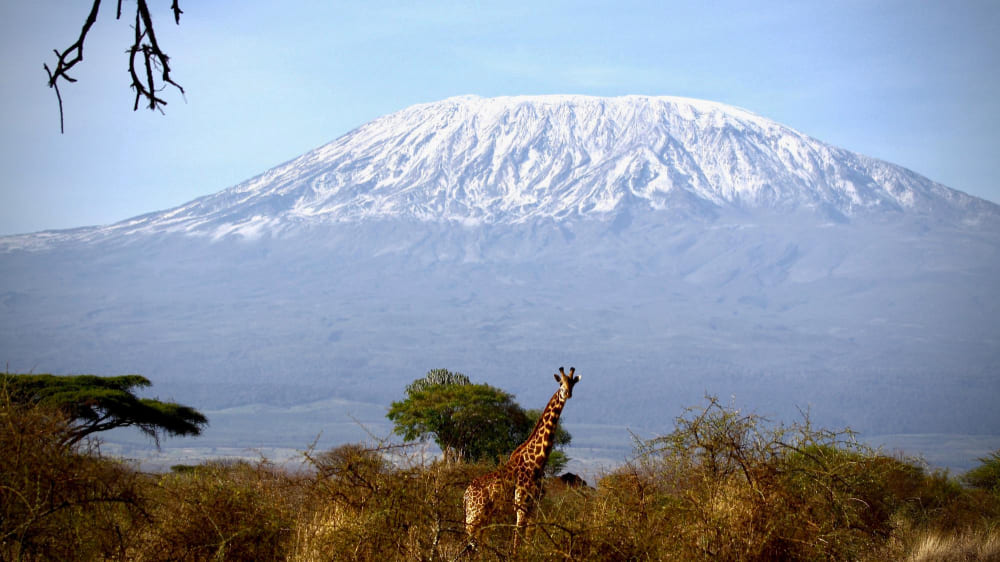
The climb begins in the Machame Forest, where thick vegetation, damp air, and towering trees make the first days feel enclosed and quiet. As the trail rises onto the Shira Plateau, the forest drops away and the views open wide, with long horizons and a sense of space that makes the altitude easier to notice.
Barranco Wall is one of the most memorable sections, not because it is technical, but because it asks for steady focus as you climb and scramble with the mountain right in front of you. The route passes Lava Tower as part of the acclimatization process, a stark, volcanic outcrop that emphasizes how quickly the environment has shifted since the lower slopes.
Trek Details
Summit night moves through Stella Point first, where many hikers catch their breath as the sky begins to change color. The final push to Uhuru Peak comes slowly, with cold air, measured steps, and the feeling that the mountain is setting the pace. From higher sections of the route, views stretch toward Mount Meru and across the surrounding plains, grounding the climb in a sense of scale that stays with you long after the descent begins.
15. Tour du Mont Blanc
The Tour du Mont Blanc (TMB) is one of the most popular long-distance hikes in Europe, encircling the Mont Blanc massif. This trek offers stunning alpine scenery, including glaciers, meadows, and high mountain passes, while crossing through three countries. It’s known for its challenging ascents and descents.

Starting out in the Chamonix Valley, the trail wastes no time climbing into open terrain, with constant reminders of how close the glaciers and peaks really are. Crossing into Italy brings you down toward Courmayeur, where the mountains feel steeper and more compact, and villages sit tightly against the slopes.
The route shifts again in Switzerland around Champex-Lac, where forests, pastures, and a slower pace briefly take over. High passes like Col de la Seigne mark the transitions between countries, with wide views that make the effort feel practical rather than dramatic. Walking near the Glacier de Bionnassay adds a colder, quieter edge to the experience, with ice and rock shaping the trail’s direction.
Trek Details
Traditional alpine villages appear regularly along the circuit, offering natural pauses that feel integrated into the walk instead of interruptions, reinforcing the sense that this route has been used and lived in long before it became a named trail.
Hard Hikes
16. The Long Range Traverse
The Long Range Traverse is a challenging backcountry trek through the rugged terrain of Gros Morne National Park in Newfoundland. This route takes hikers through pristine wilderness, offering dramatic fjords, alpine plateaus, and stunning vistas. It requires strong navigation skills and self-sufficiency.
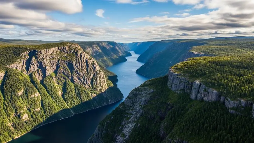
The Long Range Traverse cuts across the highlands of Gros Morne National Park with no marked trail and very little margin for distraction. The route moves past Western Brook Pond, a landlocked fjord carved deep into the mountains, where cliffs rise straight from still water and the sense of scale settles in quickly.
Trek Details
From there, the terrain climbs toward Gros Morne Mountain, with long stretches of exposed rock and tundra that feel closer to the Arctic than the rest of eastern North America. The landscape stays sparse and open, shaped by wind and weather more than vegetation.
Wildlife is part of the experience, with caribou crossing high plateaus and moose appearing in lower valleys, often without warning. Coastal views open up unexpectedly near the edges of the range, where the land drops away toward the Gulf of St. Lawrence
17. Backbone Trail
The Backbone Trail stretches across the Santa Monica Mountains, offering hikers diverse landscapes, from coastal cliffs to lush canyons. This challenging trek provides stunning views of the Pacific Ocean and the chance to experience Southern California’s unique flora and fauna.
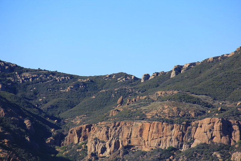
Large sections pass through Point Mugu State Park, where the trail climbs into open ridgelines and drops into quiet canyons with little sign of the city below. Sandstone Peak stands as the highest point in the range, and the short side hike to the summit delivers wide views that stretch across mountains and ocean on clear days.
Trek Details
The Mishe Mokwa Trail adds some of the most textured walking on the route, winding past volcanic rock formations and narrow ridges that keep you paying attention. Farther east, the Backbone passes through Malibu Creek State Park and Will Rogers State Historic Park, where the terrain softens, and the trail blends into a mix of grasslands, oak trees, and rolling hills.
Coastal and mountain views trade places constantly, keeping the walk visually varied. Wildlife fits naturally into the experience, with deer moving through shaded areas and birds of prey circling above the ridges, reminding you that this long path still belongs to the landscape first.
18. Everest Base Camp Trek
The Everest Base Camp Trek is one of the most iconic and challenging treks in the world, leading adventurers to the base of the highest mountain on Earth. This trek offers breathtaking views of the Himalayas, a glimpse into Sherpa culture, and a profound sense of achievement.

The trek settles into a rhythm quickly, starting with the climb to Namche Bazaar, where bakeries, gear shops, and acclimatization days make it feel like a working mountain town rather than a stop along a trail. From there, the path rises toward Tengboche Monastery, perched on a ridge with wide views that often stop people mid-step, especially when Everest appears between clouds.
Trek Details
Higher up, villages like Dingboche and Lobuche feel more exposed, with fewer trees, colder air, and days shaped by altitude and weather rather than distance. The Khumbu Glacier runs alongside parts of the route, rough and constantly shifting, a reminder that this landscape is still in motion.
Many hikers head up Kala Patthar for panoramic views, especially at sunrise, when Everest, Lhotse, and Nuptse line up clearly against the sky. Reaching Everest Base Camp itself feels quieter than expected, marked more by its setting beneath the icefall than by a single defining moment, bringing the trek to a close through accumulation rather than spectacle.
19. The Annapurna Circuit Trek
The Annapurna Circuit Trek is one of the most popular and challenging treks in Nepal, circumnavigating the Annapurna Massif. The trail passes through diverse landscapes, from subtropical forests to alpine terrain, and crosses the Thorong La Pass, one of the highest trekking passes in the world.
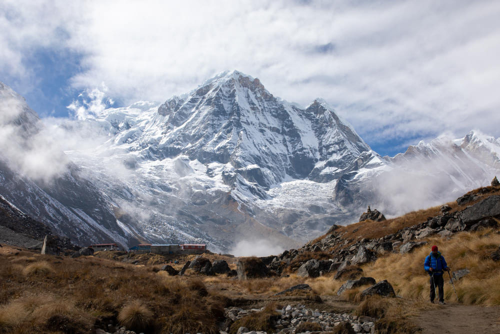
The walk through the Manang Valley is often where that rhythm settles in, with dry air, wide views, and days shaped by acclimatization rather than speed. Thorong La Pass sits at 5,416 meters and tends to dominate the planning, with an early start, steady pacing, and weather playing a bigger role than distance.
Trek Details
Some trekkers add the side trip to Tilicho Lake, which brings a colder, more exposed feel and a sense of real remoteness that contrasts with the main route. After the pass, the trail drops toward Muktinath Temple, an important pilgrimage site where trekkers and pilgrims share the same stone paths and courtyards.
The descent into the Kali Gandaki Gorge makes the scale of the region clear, with Annapurna on one side and Dhaulagiri on the other, rising above what is considered the deepest gorge in the world.
20. The John Muir Trail via Yosemite Valley
The John Muir Trail (JMT) is a long-distance trail in the Sierra Nevada mountain range of California. This challenging trek passes through several national parks, including Yosemite, Kings Canyon, and Sequoia, offering hikers breathtaking alpine scenery, high mountain passes, and remote wilderness.

The trail climbs steadily away from the crowds, and an optional side trip up Half Dome gives an early sense of how physical this route can be. Once past Yosemite, the walking opens into the Ansel Adams Wilderness, where long stretches of trail pass through high country shaped by ice, water, and distance rather than landmarks.
Evolution Valley tends to slow people down, not because the trail is difficult, but because the setting invites lingering. Meadows, river crossings, and wide basins make the days feel balanced and unhurried. Farther south, the route cuts through Kings Canyon National Park and into Sequoia National Park, where elevation gains stack up and the terrain grows more serious.
Trek Details
The final push toward Mount Whitney brings thin air, early starts, and a clear sense of direction as the trail narrows its focus. Standing on the highest peak in the contiguous United States feels like a natural conclusion to weeks of steady movement, shaped by accumulated miles rather than a single dramatic moment.
21. The Jordan Trail
The Jordan Trail is a long-distance hiking route that traverses the entire country of Jordan, from the northern forests and farms to the desert landscapes in the south. Fortunately, although being quite a long hike, it’s not desert-only.
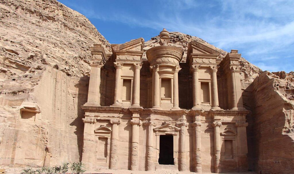
Like Camino de Santiago, this hike has a spiritual value. Even though it’s not exactly a pilgrimage, it goes through Biblical landmarks such as Umm Qais and, of course, one of the 7 modern wonders of the world, Petra.
In the north, the route passes near the Roman ruins of Jerash, where columns, theaters, and paved streets sit just beyond farmland and modern towns, making ancient history feel close rather than remote. Not far away, Ajloun Castle rises above forested hills, a reminder of how strategically important this region once was.
Trek Details
As the trail continues south, the terrain opens into the Dana Biosphere Reserve, where steep canyons, changing ecosystems, and long descents shape some of the most physically engaging days on the route. Reaching Petra on foot adds depth to the experience, with the ancient Nabatean city unfolding gradually instead of appearing all at once.
Beyond Petra, the landscape strips back to its essentials in Wadi Rum, where desert plains, sandstone towers, and long distances reset your sense of scale. The trail also traverses parts of the Jordan Rift Valley, dropping into low, dry ground before climbing again, highlighting the significant elevation and contrast packed into a single country.
Very Hard Hikes
22. The Fish River Canyon
The Fish River Canyon hike is a demanding trek through one of the largest canyons in the world. This trek takes hikers along the canyon floor, offering spectacular views of the rocky landscape, hot springs, and the winding Fish River. Due to the harsh conditions, this hike requires physical fitness and preparation.

The viewpoints along the canyon rim give way to long hours below, where scale becomes something you feel in your legs instead of something you photograph. Sulphur Springs appear quietly along the route, small signs of underground movement in an otherwise dry landscape. The rock formations tell their story slowly, with exposed layers and eroded walls showing just how old this place really is.
Trek Details
Reaching Ai-Ais Hot Springs at the end of the hike feels less like a reward and more like a natural conclusion, where warm water and tired muscles finally meet.
Desert plants and animals show up in subtle ways throughout the walk, adapted to heat and distance rather than abundance. When night falls, the lack of light pollution turns the sky into part of the experience, with stars stretching across the canyon and reinforcing how remote this route truly feels.
23. Kungsleden (The King’s Trail)
Kungsleden, or The King’s Trail, is Sweden’s most famous long-distance hike, traversing through some of the most remote and stunning landscapes in the country. Starting in Abisko, the trail immediately sets a tone of wide valleys, clear rivers, and long views that make the distance ahead feel manageable one day at a time.
")
As you move south, the landscape shifts gradually, with mountains giving way to broad plateaus, lakes, and river crossings that shape the rhythm of each section. Mount Kebnekaise, Sweden’s highest peak, stays within reach of the trail and draws many hikers onto side routes, adding a more alpine feel to parts of the walk.
Trek Details
Sections near Sarek National Park feel especially remote, with fewer signs of infrastructure and a stronger sense of isolation that makes weather and navigation part of the daily conversation. Sami villages appear along the way, grounding the route in a working landscape shaped by reindeer herding and seasonal movement rather than tourism alone.
The trail consistently crosses large lakes and braided rivers, often using boats or bridges that break the walk into natural stages. Walking from Abisko to Hemavan highlights the scale of the Arctic Circle region, and for those finishing in late summer or early autumn, clear nights sometimes bring views of the Northern Lights, closing out long days with something simple and unexpected rather than planned.
24. The Great Divide Trail
The Great Divide Trail (GDT) is one of North America’s most challenging and rewarding long-distance hikes, following the Continental Divide through the Canadian Rockies. It’s linking long stretches of protected land into a route that feels as demanding as it is expansive. It begins in Waterton Lakes National Park, where open grasslands meet sharp mountain ridges, and the trail quickly leaves any sense of frontcountry hiking behind.
Moving north, the route threads through Banff, Yoho, and Jasper National Parks, crossing high passes, remote valleys, and long sections where the path is faint or completely absent. Kananaskis Country fills in much of the middle ground, adding rugged terrain and fewer services, which makes planning and self-reliance part of the experience rather than an afterthought.
Trek Details
Alpine meadows and glaciers define much of the walking, with elevation gain coming steadily and views that stretch across entire ranges instead of single peaks. Wildlife is not a side note on the GDT, as bears, moose, and mountain goats all share the same corridors, shaping how you move, camp, and stay alert each day.
25. Pacific Crest Trail
The Pacific Crest Trail (PCT) is one of the longest and most challenging hiking trails in the world. It goes from border to border, from Mexico to Canada, through California, Oregon, and Washington. The trail traverses diverse landscapes, including the deserts of Sonoran and Mojave, the mountains of Sierra Nevada, and the forests of Oregon, offering hikers a lifetime of experiences.
The Mojave Desert sets a demanding tone early on, with heat, long water carries, and wide open terrain that asks you to think ahead every day. The shift into the Sierra Nevada Mountains is dramatic, bringing high passes, granite basins. Walking through Yosemite adds familiar landmarks, but seen slowly and on foot, they feel less iconic and more like part of a larger system of valleys and ridges.
Trek Details
Farther north, Crater Lake appears almost suddenly, its deep blue surface standing out after weeks of forest and volcanic terrain. The Cascade Range keeps the trail moving through lava fields, dense woods, and broad views, with peaks like Mount Shasta and Mount Rainier rising into view long before you get close to them.
Due to the seasonality, it’s very hard to do a hike-thru within one year. Though not being a spiritual destination, PCT is often chosen to spend a sabbatical.
Extremely Hard Hikes
26. Dientes Circuit Trek
The Dientes Circuit on Navarino Island feels like a trek that keeps its distance from expectations. The jagged Dientes de Navarino peaks dominate the skyline almost immediately, sharp and uneven, giving the route its character and its name.
As the trail climbs and drops between valleys, views open toward the Beagle Channel, where the water and distant land make the southern edge of South America feel very close and very far at the same time. Laguna del Salto appears along the way as a quiet pause in an otherwise demanding landscape, with still water reflecting peaks that rarely look the same twice.
Paso Virginia marks the highest point of the circuit and often becomes the mental center of the walk. Reaching it depends heavily on weather, snow conditions, and timing, which keeps decision-making front and center.
Trek Details
What stays consistent throughout the circuit is the sense of remoteness. There are no villages, no services, and very little evidence of human presence, which makes the Dientes Circuit feel less like a route you follow and more like terrain you carefully move through, one deliberate step at a time.
Being overshadowed by its easier and obviously more popular “neighbor” Torres del Paine, this route is only taken by several hundred per year. That’s why its obvious highlight is solitude.
27. The West Coast Trail
The West Coast Trail is a challenging and iconic hike along the rugged west coast of Vancouver Island in British Columbia. This trail, originally designed to assist shipwreck survivors, offers a demanding trek through dense forests, over rocky beaches, and along cliffs.
The trail quickly makes it clear that this is a working coastline shaped by risk and history, starting near the Pachena Point Lighthouse, which was built after a series of deadly shipwrecks offshore. Tsusiat Falls drops straight onto the sand and feels like a natural place to stop, wash up, and reset before continuing down the coast. A short boat crossing at Nitinaht Narrows breaks up the walk and highlights how this trail still intersects with communities that rely on the ocean.
Trek Details
Along certain beaches, you might notice rusted metal, old boilers, or fragments of hulls emerging from sand and driftwood, including remains linked to vessels like the Michigan, which ran aground near Pachena Point in 1893, and the Valencia, a passenger steamship that sank in 1906 with heavy loss of life. These wrecks are part of the reason the original lifesaving trail was established here.
Forest sections slow things down with ladders, mud, and cable cars, especially after rain. Wildlife stays part of the daily awareness, with bears and cougars moving through the same corridors and seals, whales, and sea lions sometimes visible offshore.
28. Dolomite High Route (Alta Via Uno)
The Dolomite High Route, often called Alta Via Uno, starts at Lago di Braies, where still water and pale limestone set expectations early. The trail moves quickly into classic Dolomite terrain, with sharp ridgelines, open meadows, and long traverses that keep the scenery changing without feeling rushed.
")
Massive formations like Tofana di Rozes dominate entire sections of the walk, shaping both the views and the route itself. Cinque Torri stands out for its clustered rock towers and the traces of World War I history scattered through the area, adding context to the walking rather than distraction.
Optional side trips, such as the route toward the Marmolada Glacier, add a more alpine feel, with colder air and terrain that feels closer to high mountain travel than hut-to-hut hiking.
Trek Details
Passing near Cortina d’Ampezzo briefly brings the trail close to roads and town life, which makes the return to quieter ground feel sharper. Peaks like Piz Boè rise above long stretches of the route, anchoring the experience in elevation and exposure rather than distance.
What defines Alta Via Uno is how consistently it balances accessibility and seriousness, offering demanding days, reliable mountain huts, and a landscape that never lets you forget you are moving through one of Europe’s most distinctive ranges.
29. GR20
The GR20 is one of the toughest long-distance hikes in Europe. It traverses the rugged mountains of Corsica, offering dramatic scenery that includes high peaks, deep valleys, and picturesque villages. The trek requires strong physical fitness and mountaineering skills.
Much of the route remains high and exposed, traversing rugged terrain where footing is crucial and days feel full, even without covering long distances.
Monte Cinto, the highest peak in Corsica, looms over the northern section, and nearby stages around the Asco Valley tend to be some of the most physically demanding, with steep ascents and long, rocky descents that slow everything down.
Trek Details
Farther south, the character of the route shifts again near the Bavella Needles, where jagged rock formations rise sharply above pine forest, and the trail weaves through narrow passes and open viewpoints.
What ties the GR20 together is how little it softens the experience. It stays raw, physical, and focused on movement through the landscape, making each section feel earned rather than scenic by default.
30. Snowman Trek
The Snowman Trek is one of the world’s most challenging and remote treks, traversing the high Himalayas of Bhutan. This trek takes hikers through some of Earth’s most pristine and unspoiled landscapes, including high mountain passes, glacial valleys, and traditional Bhutanese villages and Buddhist monasteries. It traverses 9 passes higher than 4,500 m/14,800 ft and 6 mountains above 7,000 m / 23,000 ft.

The journey usually begins near Paro Taktsang, the Tiger’s Nest Monastery, perched high on a cliff and setting a reflective tone before the trail moves into far more remote ground. From there, the route climbs steadily toward Jomolhari Base Camp, where wide valleys and massive peaks make it clear that this trek is shaped by altitude and distance more than speed.
Trek Details
Villages like Laya and Thanza feel essential to the rhythm of the walk, offering rare pockets of daily life in a landscape dominated by rock, ice, and high pasture. These settlements are not quick stops, and time spent here often depends on weather, acclimatization, and the condition of the passes ahead.
High crossings such as Gophu La and Rinchen Zoe La define the route, with elevations, exposure, and unpredictable conditions forcing careful pacing and long days. The Snowman Trek does not rely on a single highlight to carry the experience. It unfolds through effort, isolation, and repetition, making it a route where progress itself becomes the focus and every pass crossed feels fully earned.
Read more
Pin this for later