Did you know that studies show hiking for just 90 minutes can significantly boost your mood and reduce stress? Whether you’re a complete novice looking to dip your toes into the hiking world or a seasoned walker seeking a leisurely stroll through stunning landscapes, we’ve got you covered. From the rolling hills of Tuscany to the dramatic coastlines of Ireland, these 10 best hikes in Europe for beginners will leave you feeling accomplished, refreshed, and absolutely enchanted. So grab your water bottle and let’s explore some of Europe’s most accessible natural wonders!
- Cinque Terre Coastal Trail
- Trail Highlights
- Killarney National Park Ring Walk
- Wildlife Spotting Guide in Killarney National Park
- Keukenhof Gardens to Flower Fields
- Tulip Blooming Calendar
- Plitvice Lakes Wooden Walkways
- Plitvice Lake System Overview
- Saxon Switzerland National Park
- Featured Routes
- Hallstatt Lakeside Walk
- Cultural Attractions Along the Hallstatt Lakeside Route
- Cotswolds Countryside Paths
- Village Hopping Routes
- Camino Portugués Coastal Route
- Recommended Camino Portugués Day Sections for Beginners
- Black Forest Panorama Trail
- Lofoten Islands Beach Walks
- Featured Beach Walks
- Midnight Sun Schedule
- Essential Hiking Gear Checklist
- Must-Have Items
- Nice-to-Have Items
- Planning Your European Hiking Adventure
- Season-by-Season Guide
- Budget Planning Guide for Hiking in Europe
- Transportation Between Hikes
- Useful Resources for Hikers in Europe
Cinque Terre Coastal Trail
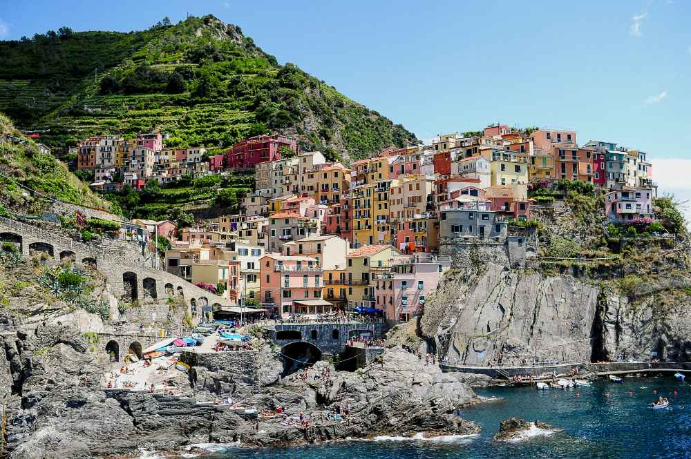
Walk between picturesque fishing villages along the Italian Riviera. Cinque Terre, a UNESCO World Heritage site, offers well-maintained paths with stunning Mediterranean views and moderate distances with plenty of rest stops and cafes.
Trek Details
Trail Highlights
The Cinque Terre trail connects five charming villages: Monterosso al Mare, Vernazza, Corniglia, Manarola, and Riomaggiore. Each village offers:
- Monterosso al Mare – Sandy beaches and lemon groves
- Vernazza – Medieval castle and harbor views
- Corniglia – Hilltop vineyards and panoramic vistas
- Manarola – Colorful cliffside houses
- Riomaggiore – Authentic fishing village atmosphere
Killarney National Park Ring Walk
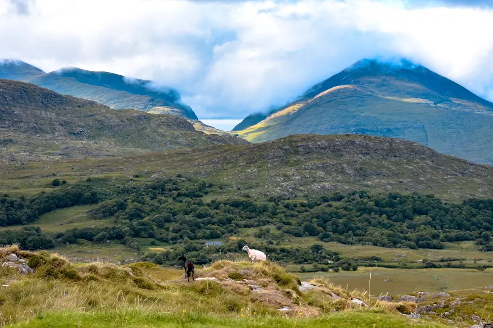
Explore Ireland’s first national park on gentle, well-marked trails. Discover pristine lakes, ancient oak forests, and charming wildlife. Perfect for families with multiple shorter loop options.
Trek Details
This loop offers a taste of Killarney’s diverse landscape: lakeside views, shaded woodlands, open fields, and glimpses of the MacGillycuddy’s Reeks, without requiring lengthy travel or tough terrain.
Wildlife Spotting Guide in Killarney National Park
| Animal | Best Viewing Time | Location | Likelihood |
|---|---|---|---|
| Red Deer | Early morning/evening | Open meadows | High |
| Irish Hare | Dawn/dusk | Grasslands | Medium |
| Golden Eagle | Midday | Mountain peaks | Low |
| Grey Seal | Any time | Lake shores | Medium |
Keukenhof Gardens to Flower Fields
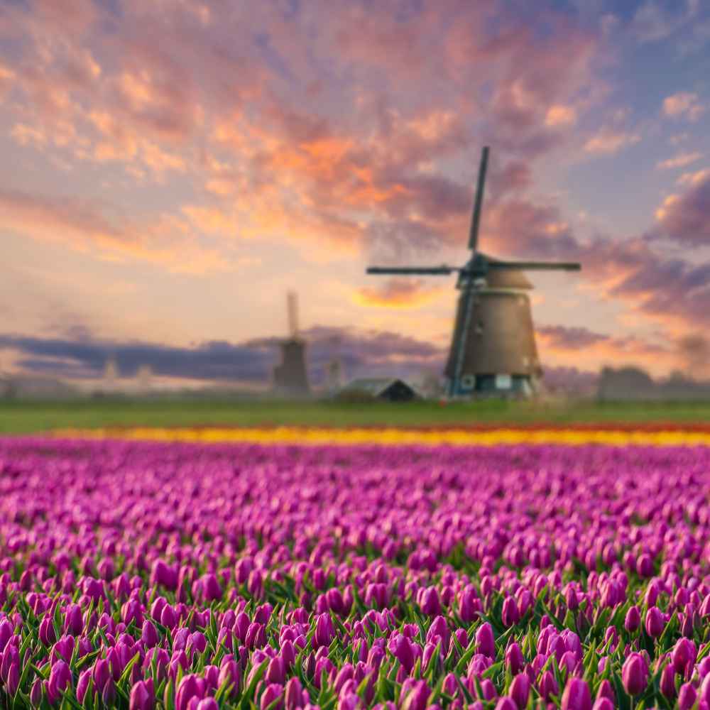
Keukenhof, Netherlands, is the world’s #1 flower festival, but its venue size makes it a great and easy hike. It’s open from mid-March to mid-May, covering 32 hectares and featuring around 7,000,000 flower bulbs planted in carefully curated displays. Over 800 types of tulips are arranged to bloom in succession, creating vibrant patterns and color shifts throughout the season.
The garden features themed pavilions, various landscape zones, including Japanese and English gardens, as well as sculptural art pieces situated among the flowers. A traditional Dutch windmill and canal-side boat rides add to the experience. About 15 kilometers of flat, paved paths make the park easy to explore on foot, and there are areas for picnics, a children’s playground, and even a hedge maze. The paths are easy for all fitness levels.
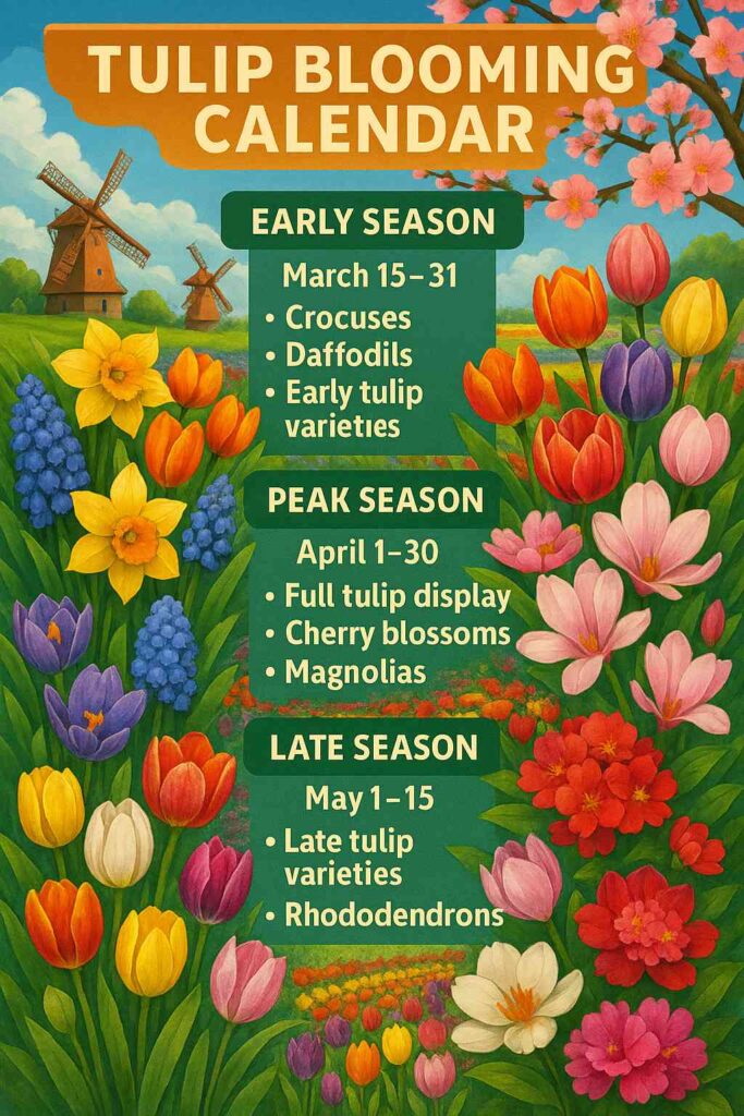
Tulip Blooming Calendar
Plitvice Lakes Wooden Walkways
Plitvice Lakes National Park, with its multiple routes, is one of the most epic hikes in the world. There, you can walk on elevated wooden boardwalks over crystal-clear lakes and marvel at cascading waterfalls and vibrant turquoise waters. The routes are clearly marked with minimal elevation changes.
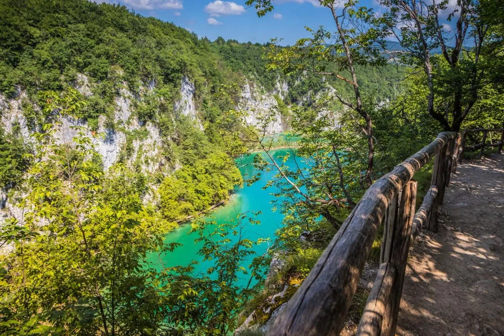
Plitvice Lake System Overview
The park features 16 terraced lakes connected by waterfalls and cascades. The lakes are divided into:
Upper Lakes (Gornja jezera):
- Larger, more forested area
- 12 interconnected lakes
- Higher elevation (636-750m)
Lower Lakes (Donja jezera):
- 4 smaller lakes
- More dramatic waterfalls
- Lower elevation (503-636m)
Trek Details
Saxon Switzerland National Park
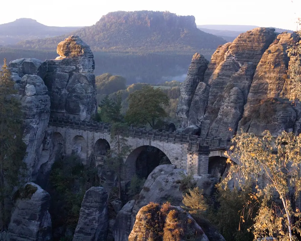
Saxon Switzerland National Park, located in eastern Germany near the Czech border, is one of the most visually distinctive landscapes in Europe. Covering 93 km², it protects the core of the Elbe Sandstone Mountains.
The region is known for its vertical rock pinnacles, deep forested gorges, table mountains, and eroded cliff formations that rise dramatically above the Elbe River.
Featured Routes
For walkers, Saxon Switzerland offers an extensive trail network, including the 112 km Malerweg (Painter’s Way), inspired by the Romantic artists who frequented the region. Villages like Rathen, Bad Schandau, and Königstein serve as trailheads and access points via regional trains and river ferries.
Bastei Bridge Circuit:
- Famous sandstone bridge with panoramic views
- Restaurant and visitor facilities
- Well-maintained pathways
Lilienstein Table Mountain:
- Gentle ascent to a flat-topped mountain
- 360-degree views of the Elbe Valley
- Ancient fortress site
The park borders Bohemian Switzerland National Park in the Czech Republic, forming a cross-border conservation area. What makes Saxon Switzerland unique is the ability to hike from dark forest gorges to elevated, panoramic cliffs in a matter of minutes, with terrain that feels sculpted for adventure.
Hallstatt Lakeside Walk
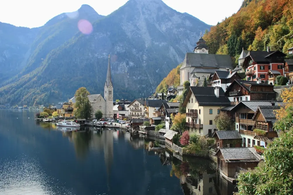
The Hallstatt Lakeside Walk runs along the edge of the stunning Hallstätter See in Austria’s Salzkammergut region. This flat, culturally rich lakeside promenade connects the UNESCO-listed town of Hallstatt with the scenic villages of Steeg and Obertraun.
With the towering Dachstein Alps as a backdrop, the walk delivers a timeless Alpine setting, complete with traditional salt-mine architecture and rustic lakeside cafés.
Trek Details
Cultural Attractions Along the Hallstatt Lakeside Route
Along the way, you’ll pass through some of Austria’s most interesting cultural sites, making it easy to combine a relaxing walk with meaningful stops.
One of the most unique places is the Hallstatt Ossuary, located just above the Catholic Church. For centuries, limited burial space in this small village led locals to exhume graves and carefully stack the skulls and bones inside a chapel.
Not far from the start of the walk, you can also visit the Hallstatt Salt Mine, believed to be the oldest in the world. A short ride up the funicular brings you to the mine entrance, where guided tours take you deep underground. You’ll see wooden slides used by miners, salt-carved tunnels, and even a hidden salt lake.
| Attraction | Description | Duration | Entry Fee |
|---|---|---|---|
| Hallstatt Salt Mine | Historic salt production site | 90 minutes | €32 adults |
| Bone House | Unique ossuary with painted skulls | 30 minutes | €2 |
| Market Square | Historic town center | 30 minutes | Free |
| Lake Boat Tour | Scenic water perspective | 45 minutes | €15 |
| Skywalk | Views of the lake and village below | 30 minutes | Funicular round-trip (valley ↔ Skywalk): €24 for adults |
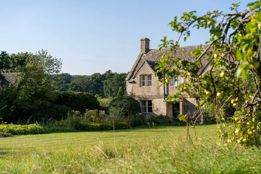
Cotswolds Countryside Paths
Wander through quintessentially English villages and rolling hills. Follow well-maintained public footpaths with excellent signage. Experience charming pubs and tea rooms along the route.
Village Hopping Routes
Village-hopping through the Cotswolds is one of the best ways to experience the charm of England’s countryside. These walks take you across rolling pastures, through hedgerow-lined paths, and into honey-colored villages with centuries of history and well-kept tea rooms.
The Classic Cotswolds Triangle:
- Chipping Campden → Broadway → Stanton
- Distance: 8 km
- Highlights: Medieval market town, Broadway Tower
- Bourton-on-the-Water → Lower Slaughter → Upper Slaughter
- Distance: 6 km
- Highlights: “Venice of the Cotswolds,” model village
- Stow-on-the-Wold → Naunton → Guiting Power
- Distance: 10 km
- Highlights: Antique shops, Norman churches
Camino Portugués Coastal Route
The caminos are countless, with the longest reaching up to 1000s of kilometers; however, not many pilgrims have that much time and stamina, opting instead for the shorter camino walks. Basically, you need only 100 km of any route to get your compostela certificate.
But even if the shortened Camino seems too much, you can walk just specific sections of this famous pilgrimage route along stunning coastlines. Choose from various distances to match your comfort level. Enjoy excellent infrastructure with accommodations and facilities.
Recommended Camino Portugués Day Sections for Beginners
| Section Start | End | Distance | Highlights |
|---|---|---|---|
| Porto | Vila do Conde | 18 km | Historic Porto, coastal views |
| Vila do Conde | Póvoa de Varzim | 12 km | Beach walking, lighthouse |
| Esposende | Viana do Castelo | 20 km | Riverside paths, medieval town |
| Viana do Castelo | Vila Praia de Âncora | 15 km | Coastal cliffs, fishing villages |
The Portuguese Coastal Camino begins in Porto, where the route leaves the historic Sé Cathedral and quickly joins the Atlantic coast. The first stage to Vila do Conde is about 18 km, with wide boardwalks and promenades leading north past beaches and fishing harbors. Walkers enjoy a mix of city energy and fresh sea air, with the Douro River estuary behind and sand dunes unfolding ahead.
From Vila do Conde to Póvoa de Varzim (12 km), the walk continues along the shoreline with more beach views, small chapels, and the Farol de Regufe—a 19th-century red iron lighthouse. This stage is short and relaxed, ideal for a morning stroll and seaside lunch.
The next segment, Esposende to Viana do Castelo (20 km), is more rural. It weaves through riverside paths and pine forest, crosses the Cávado River via a scenic bridge, and ends in a well-preserved medieval town with tiled facades and iron balconies. Viana’s Santa Luzia basilica offers one of the best viewpoints on the route.
From Viana do Castelo to Vila Praia de Âncora (15 km), the scenery becomes more rugged. The path hugs coastal cliffs and passes fishing villages with stone houses and quiet harbors, offering a more intimate, authentic stretch of the northern coast.
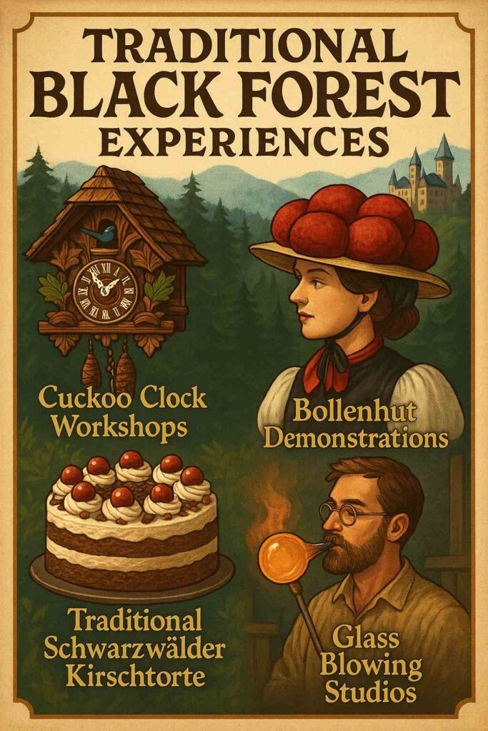
Black Forest Panorama Trail
Explore gentle forest paths with panoramic valley views. Experience traditional German culture in charming villages. Follow well-marked trails with numerous rest areas and viewpoints.
Trek Details
This trail delivers gentle elevation with consistent panoramic views across wooded ridges. Highlights include the baroque church of St. Märgen, vantage points opening into the Rhine Plain and distant Vosges, and a quiet farm country atmosphere.
It’s an excellent introduction to Black Forest walking — accessible yet scenic, well‑signposted by the Schwarzwaldverein, and perfect for a refreshing outdoor escape.
Lofoten Islands Beach Walks
Discover pristine Arctic beaches accessible via easy coastal paths. Marvel at dramatic mountain backdrops and crystal-clear waters. Experience the midnight sun during the summer months for extended hiking time.
A typical walk might start at Uttakleiv Beach, loop around the coastal path to Haukland Beach, and finish at Vik, covering about 8 km in total. The trail is mostly flat, hugging the coastline beneath steep cliffs and grassy slopes.
Despite being well above the Arctic Circle, the Gulf Stream keeps the area ice-free and surprisingly mild in summer. You’ll pass grazing sheep, sea stacks, and isolated coves—all with snow-capped peaks as a backdrop.
Another option is Ramberg to Skagsanden, a shorter route along the E10 with detours to the beach, or Kvalvika Beach, which requires a short but steep hike over a saddle into a secluded bay. Many routes are sandy or gravel paths with no technical difficulty.
Featured Beach Walks
Kvalvika Beach:
- Hidden gem accessible by gentle 3 km hike
- Pristine white sand beach
- Dramatic mountain amphitheater setting
Uttakleiv Beach:
- Easy access with parking nearby
- Iconic heart-shaped rock formations
- Perfect for midnight sun photography
Haukland Beach:
- Short walk from road
- Caribbean-like white sand
- Mountain reflections in turquoise water
Midnight Sun Schedule
| Month | Midnight Sun Period | Daylight Hours |
|---|---|---|
| May | Limited | 18-20 hours |
| June | June 1-15 | 24 hours |
| July | Full month | 24 hours |
| August | August 1-15 | 22-24 hours |
Essential Hiking Gear Checklist
Layering is key. A breathable base layer, an insulating mid-layer like a fleece, and a waterproof jacket cover most weather situations. Conditions change fast in the mountains and by the sea. A hat, gloves, and a buff take up little space but help in wind and cold snaps.
Carry water—at least a liter or more for longer routes—and snacks that don’t melt or crush. Energy bars, nuts, and dried fruit work well. A small first aid kit with blister plasters, tape, and basic painkillers is smart to have, even for short hikes.
Must-Have Items
- Comfortable walking shoes with good grip
- Weather-appropriate clothing layers
- Water bottle (minimum 1 liter)
- Snacks and energy bars
- First aid kit basics
- Map or GPS device
- Phone with emergency contacts
Nice-to-Have Items
- Trekking poles for stability
- Camera for capturing memories
- Binoculars for wildlife viewing
- Portable phone charger
- Rain jacket (European weather can be unpredictable)
Planning Your European Hiking Adventure
As easy as these hikes might seem, they do require some planning as to packing, budget and transportation.
Season-by-Season Guide
In spring, trails come to life with blooming wildflowers and fresh greenery. It’s an ideal time to explore lowland areas like the Netherlands or central France, where temperatures are moderate and fields are in full color. Still, some alpine routes may have lingering snow, so pack layers and rain gear.
Summer brings the best conditions for hiking in northern regions such as Norway, Ireland, or Scotland. Long daylight hours and stable weather make it easier to cover distance or enjoy late-evening views. However, it’s also peak season, so booking accommodation in advance is smart.
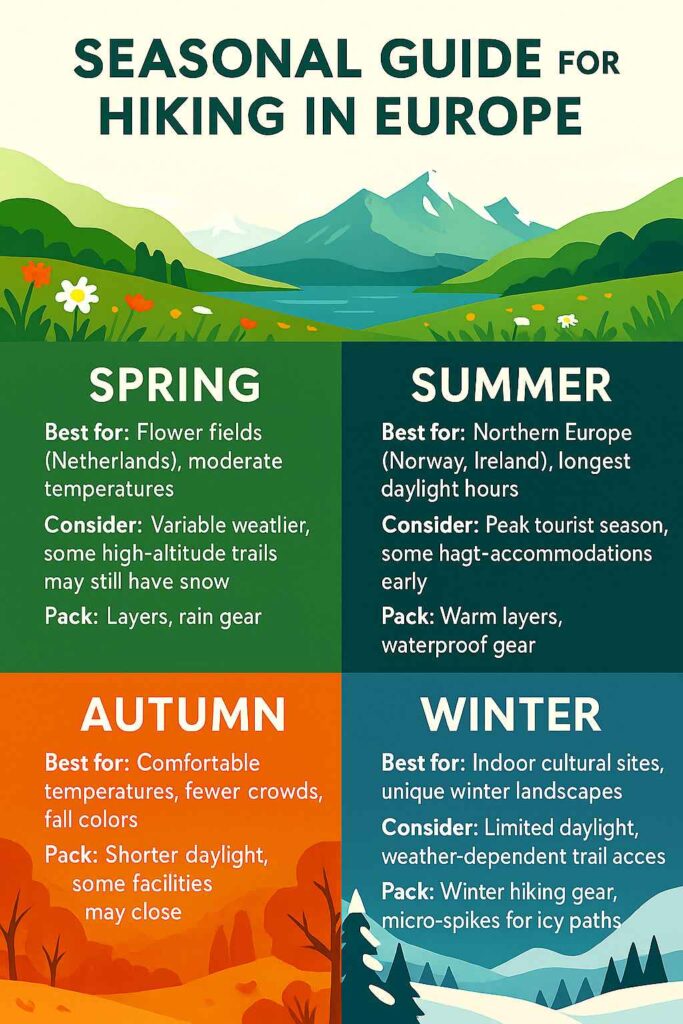
Autumn is a favorite for many hikers thanks to crisp air, rich fall colors, and quieter trails. Destinations like the Black Forest or the Italian Dolomites offer vivid scenery without the summer crowds. Just remember to plan around shorter daylight and occasional trail closures.
Winter hiking takes extra care but comes with big rewards. Snow-covered forests, frozen lakes, and peaceful trails offer a very different kind of experience. Trails may be icy, so micro-spikes and warm layers are a must. With the right preparation, every season has its own highlights.
Budget Planning Guide for Hiking in Europe
The budget-savvy approach should focus on hostels and public transportation; the best way to travel between countries and regions is by train.
| Expense Category | Daily Budget Range | Notes |
|---|---|---|
| Accommodation | €30-100 | Hostels to mid-range hotels |
| Meals | €25-50 | Mix of restaurants and packed lunches |
| Transportation | €10-30 | Local buses, trains |
| Trail Fees | €0-25 | Most trails are free, but some parks charge entry |
| Equipment Rental | €10-20 | Most trails are free, some parks charge entry |
Transportation Between Hikes
Getting between hiking destinations in Europe is easier than you might think, especially with a combination of rail and budget flights. The Eurail Pass is one of the most flexible tools for overland travel. The Flexi Pass gives you 5 to 15 travel days within a one- or two-month window, perfect for spacing out hikes over a longer trip. If you’re staying in one country, like Switzerland, Austria, or Italy, a Country Pass gives you unlimited train travel within that nation. For travelers hopping between specific neighbors (like France and Spain, or Germany and Austria), Regional Passes offer great value.
When covering longer distances or connecting to starting points not easily reached by train, budget airlines can save time and money. Ryanair has one of the broadest networks, connecting major cities to lesser-known regions. EasyJet is a strong option for tourist-heavy hubs and Alpine access points. Wizz Air is a good pick for Eastern European destinations, often flying to smaller airports close to hiking areas.
For most hiking trips, a mix of train and air travel works best. Trains cover scenic routes and remote villages; budget flights make it easy to jump between countries. Book ahead for the best prices and smooth transitions.
Useful Resources for Hikers in Europe
An essential safety tool that divides the world into 3m x 3m squares with unique three-word addresses. Critical for emergency location sharing in remote areas.
European Ramblers Association (ERA)
Official network connecting hiking organizations across 33 European countries. Provides information on long-distance European walking routes and local hiking clubs.
Pin this for later


Comments