All roads lead to Rome, or so the saying goes. But did you know that the Romans built over 250,000 miles of roads across their vast empire? These pathways were the arteries that carried the lifeblood of one of history’s greatest civilizations.
- Roman Roads at a Glance
- 1. Via Augusta: Mediterranean Spain
- Via Augusta Itinerary
- 2. Via Claudia Augusta: Trans-Alpine Route
- Via Claudia Augusta Itinerary
- 3. Fosse Way: England’s Straightest Roman Road
- Fosse Way itinerary
- 4. Via Julia Augusta: French Riviera to Italian Riviera
- Via Julia Augusta Itinerary
- 5. Ermine Street: London to Lincoln and York
- Ermine Street Itinerary
- 6. Via Appia Antica (The Appian Way)
- Via Appia Antica Itinerary
- 7. Hadrian’s Wall Path
- Hadrian’s Wall Path Itinerary
- 8. Via Francigena: Italy, France, Switzerland, England
- The Canterbury-to-Rome Pilgrim Highway
- 9. Via Domitia, France: Gateway to Gaul
- Via Domitia Route
- 10. Via Salaria, Italy: The Salt Road
- Rome’s Ancient Commodity Highway
- 11. Watling Street, England: London to North Wales
- Watling Street Route
- 12. Via Egnatia, Greece and Turkey: Eastern Empire Highway
- Via Egnatia Route
- Choosing Your Roman Road Route
Roman Roads at a Glance
What’s truly remarkable is that many of these 2,000-year-old Roman roads in Europe remain walkable today. You’re literally following in the footsteps of Roman legions, merchants, and emperors who shaped the course of European history.
| Road Name | Countries | Length | Best Travel Mode | Highlights |
|---|---|---|---|---|
| Via Augusta | Spain | 1,500 km | Car/Bus/Walking sections | Mediterranean coast, Tarragona, Roman ruins |
| Via Claudia Augusta | Germany/Austria/Italy | 500 km | Cycling/Car | Alpine crossing, medieval towns, Augsburg |
| Fosse Way | England | 320 km | Car/Walking sections | Cotswolds, Bath, Roman towns |
| Via Julia Augusta | France/Italy | 280 km | Car/Walking sections | French Riviera, Liguria, coastal views |
| Ermine Street | England | 320 km | Car/Walking sections | London |
| Via Appia Antica | Italy | 563 km | Car/Walking sections | Rome, Catacombs |
| Hadrian’s Wall Path | England | 135 km | Car/Cycling/Walking | Cumbria |
| Via Francigena | England, France, Switzerland, Italy, Vatican | 1,900 km | Train/Bus/Cycling/Walking | Religious pilgrimage |
| Via Domitia | Italy, France | 600 km | Car/Train/Walking | South of France |
| Via Salaria | Italy | 240 km | Car/Walking | Adriatic |
| Watling Street | England | 740 km | Car/Walking | London, Kent |
| Via Egnatia | Albania, North Macedonia, Greece, Turkey | 1,120 km | Car/Walking | Byzantine heritage |
1. Via Augusta: Mediterranean Spain
Approximately 1,500 km (930 mi) long, the Via Augusta was constructed to connect Spain with Italy, spanning from the southwestern coastal city of Gades (Cádiz) to the Pyrenees Mountains, following inland valleys parallel to the Mediterranean Sea coast. This road was the longest in Hispania.
- Start Point: Cádiz (ancient Gades)
- End Point: La Jonquera/Coll de Panissars (French border)
- Major Stops: Córdoba, Jaén, Valencia, Sagunto, Tarragona, Barcelona
- Best Preserved Sections: Catalonia (Tarragona to Barcelona)
- UNESCO Status: Arc de Berà (Tarragona) is protected
Built during the reign of Augustus (27 BC – 14 AD), the Via Augusta served as the backbone of Roman Hispania. Via Augusta (also known as Via Herculea or Via Exterior) was a Roman road crossing all of Hispania Province, from Cádiz in the southern tip of current Spain, to the Coll de Panissars, where it crossed the Pyrenees close to the Mediterranean Sea, and joined the Via Domitia.
Via Augusta Itinerary
The road facilitated military conquest and control and served as a trade route to transport silver, olive oil, and wine.
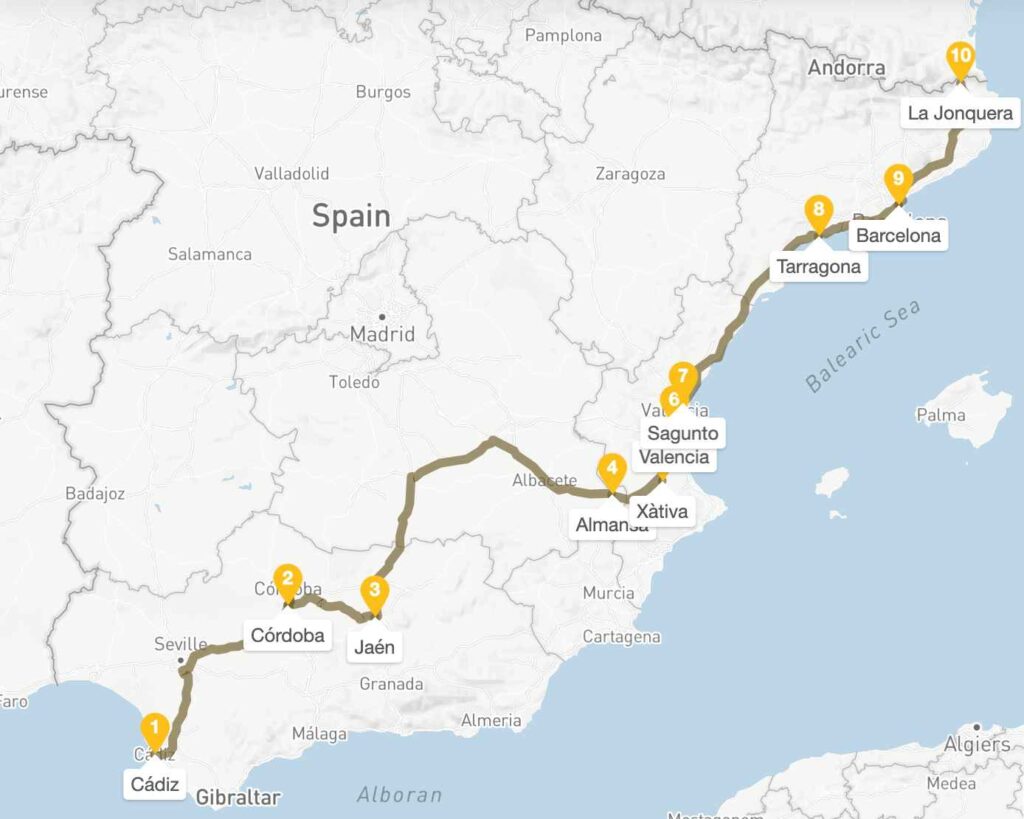
Taking the path of Via Augusta, one can get the fullest overview of the Mediterranean Spain. Starting at Cádiz, not far from Gibraltar, the southernmost point, moving up to the Northern border, passing along the key seaside cities — Barcelona and Valencia
The recommended duration is 2 weeks, but certain walking sections might be skipped, trimming down the itinerary to 10 days. Check out the Via Augusta itinerary here.
2. Via Claudia Augusta: Trans-Alpine Route
The Via Claudia Augusta is an ancient Roman road, linking the valley of the Po River with Rhaetia (encompassing parts of modern Eastern Switzerland, Northern Italy, Western Austria, Southern Germany, and all of Liechtenstein) across the Alps. This trans-Alpine route remains one of Europe’s most scenic journeys.
- Start Point: Donauwörth or Augsburg, Germany
- End Points: Venice (Altinum)
- Highest Points: Reschen Pass (1,504m) and Fernpass (1,209m)
- Countries: Germany, Austria, Italy (Switzerland briefly)
- Modern Status: Popular cycling route with excellent infrastructure
Following the footsteps of Roman legionnaires, the Via Claudia Augusta offers cyclists an unforgettable journey across the Alps, connecting Germany’s Bavarian region to northern Italy. This historic route, first developed into a proper road by Emperor Claudius in 46-47 AD, began as a crucial military and trade connection.
Via Claudia Augusta Itinerary
Emperor Claudius expanded an earlier military track into a proper Roman road to connect Germanic provinces with Mediterranean trade, facilitate troop movements across the Alps, and enable the transportation of wine and luxury goods northward.
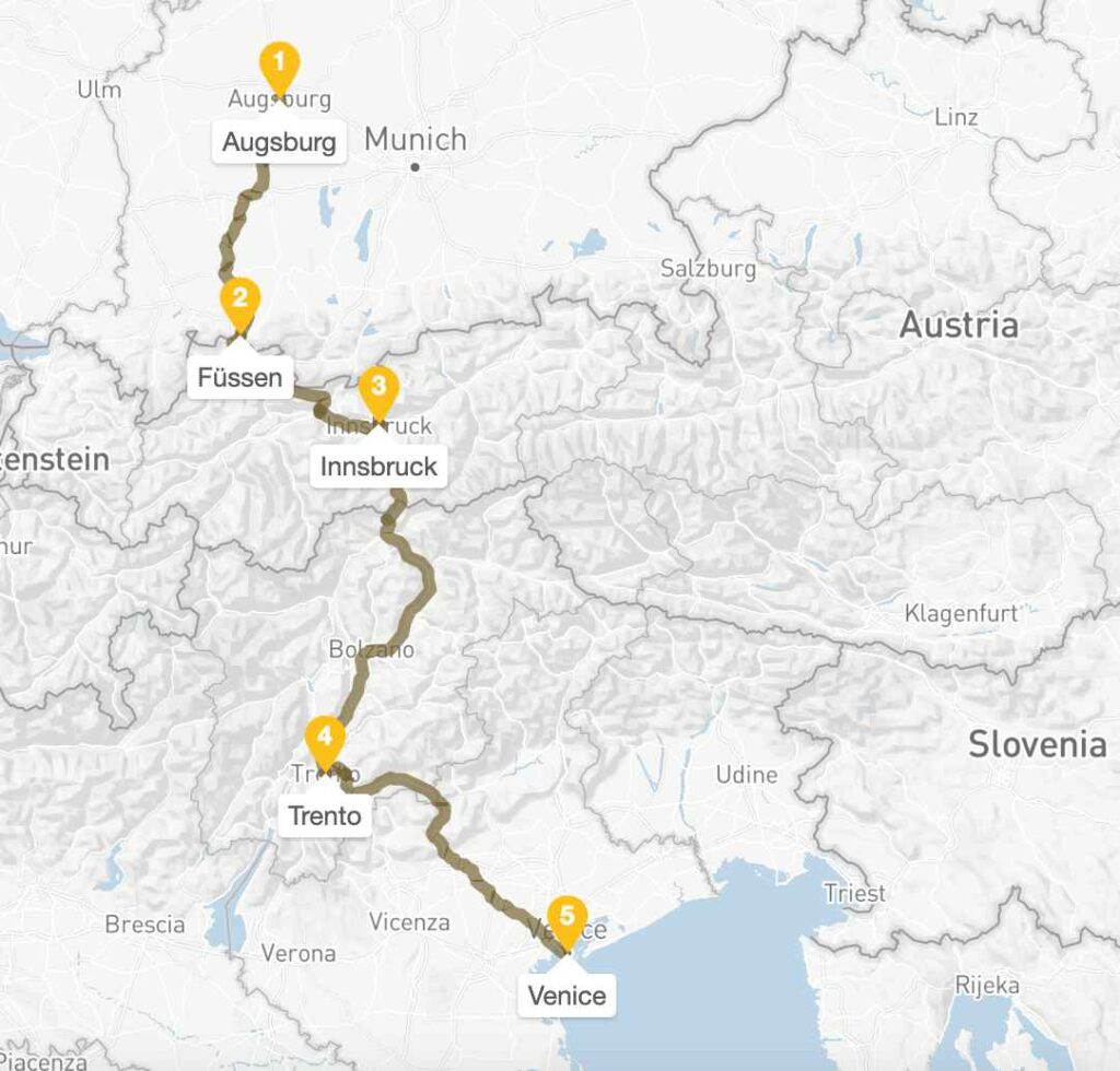
Even though the road spans 3 countries: Germany, Austria, and Italy, it’s achievable to complete it in a span of 7-10 days. The route is best done by a combination of car and bicycle, allowing one to fully contemplate the well-preserved Roman sites in Bavaria and the Austrian Tyrol.
3. Fosse Way: England’s Straightest Roman Road
One of the straightest of straight Roman roads across England, the Fosse Way runs from Exeter in Devon in the south to Lincoln in the northeast. Stretching from Exeter (Isca Dumnoniorum) in the southwest to Lincoln (Lindum Colonia) in the northeast, the Fosse Way spanned nearly 200 miles and represents Roman engineering precision at its finest.
- Length: 320 km (200 miles)
- Start: Exeter, Devon
- End: Lincoln, Lincolnshire
- Major Cities: Bath, Cirencester, Leicester
- Modern Roads: A46, A433, A429 follow much of the route
- Walking Sections: Excellent preserved stretches in the Cotswolds
Built around 47 AD following the Roman invasion under Emperor Claudius, the Fosse Way initially served as a military frontier. The word “Fosse” comes from the Latin fossa, meaning ditch, as it is believed the road may have originally been flanked by defensive ditches.
Fosse Way itinerary
The best way to explore the Fosse Way is by a combination of driving and walking; this relatively short route can be done in under 1 week.
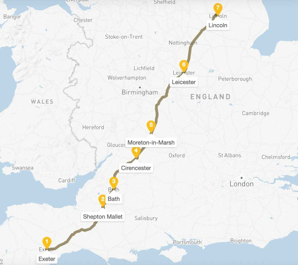
The road from Exeter to Lincoln is remarkably straight, and the experience is quintessentially English, a countryside on ancient foundations.
4. Via Julia Augusta: French Riviera to Italian Riviera
La Via Julia Augusta, constructed in the first century BC, is a Roman road that runs from current-day Piacenza, Italy to Arles, France. The coastal section from Nice to the Italian border offers spectacular Mediterranean scenery combined with Roman heritage.
- Coastal Section: Nice to Ventimiglia (50 km)
- Full Length: Piacenza to Arles (280 km)
- Best Preserved: Monaco to Menton stretch
- Highlights: Roman trophy, coastal views, medieval villages
- Modern Status: Scenic driving route, walking paths
Roman roads are always named after their founder. Julia for Jullii, Julius Caesar’s family (Emperor Augustus was his adoptive son), and Augusta for Augustus.
Via Julia Augusta Itinerary
Via Julia Augusta was built to connect Rome with its Gallic provinces.
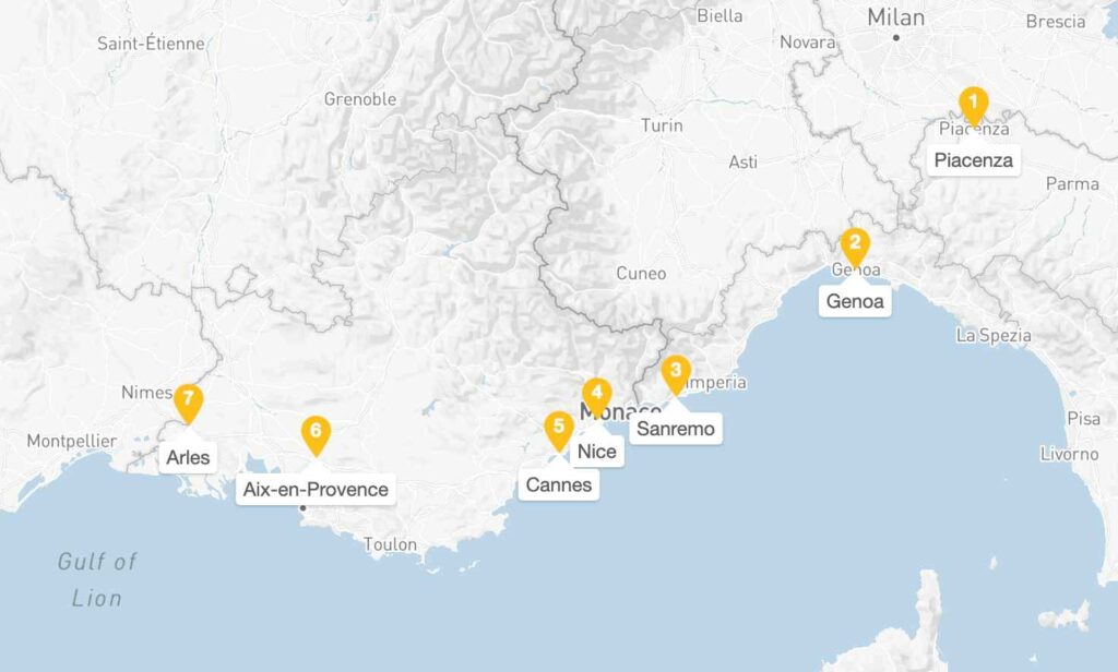
The route combines some of Europe’s most spectacular coastal scenery with exceptional Roman remains, from the Italian Riviera through Monaco and the French Riviera to the Roman treasures of Provence.
5. Ermine Street: London to Lincoln and York
Ermine Street is a major Roman road in England that ran from London (Londinium) to Lincoln (Lindum Colonia) and York (Eboracum), built within the first three decades after the Roman invasion of Britain in 43 CE. This ancient highway represents one of the most important Roman engineering achievements in Britain.
- Start Point: Bishopsgate, London (Londinium)
- End Points: Lincoln (Lindum Colonia) and York (Eboracum)
- Length: 320 km (200 miles) to Lincoln, extending to York
- Major Stops: Royston, Godmanchester, Stamford, Newark
- Modern Roads: A1 follows much of the route
- Best Preserved: Sections near Stamford in Lincolnshire and south of Ware in Hertfordshire
Built by the IX Legion as part of their advance northwards in the AD40s and 50s, Ermine Street served as Rome’s primary route into northern Britain. The road enabled rapid military deployment during the conquest of Britain and later became crucial for civilian administration and trade.
Ermine Street Itinerary
Ermine Street is best reached by car. The starting point is the Bishopsgate Area of London; the whole route can be completed in under a week. It runs through 4 counties and crosses 5 major rivers.
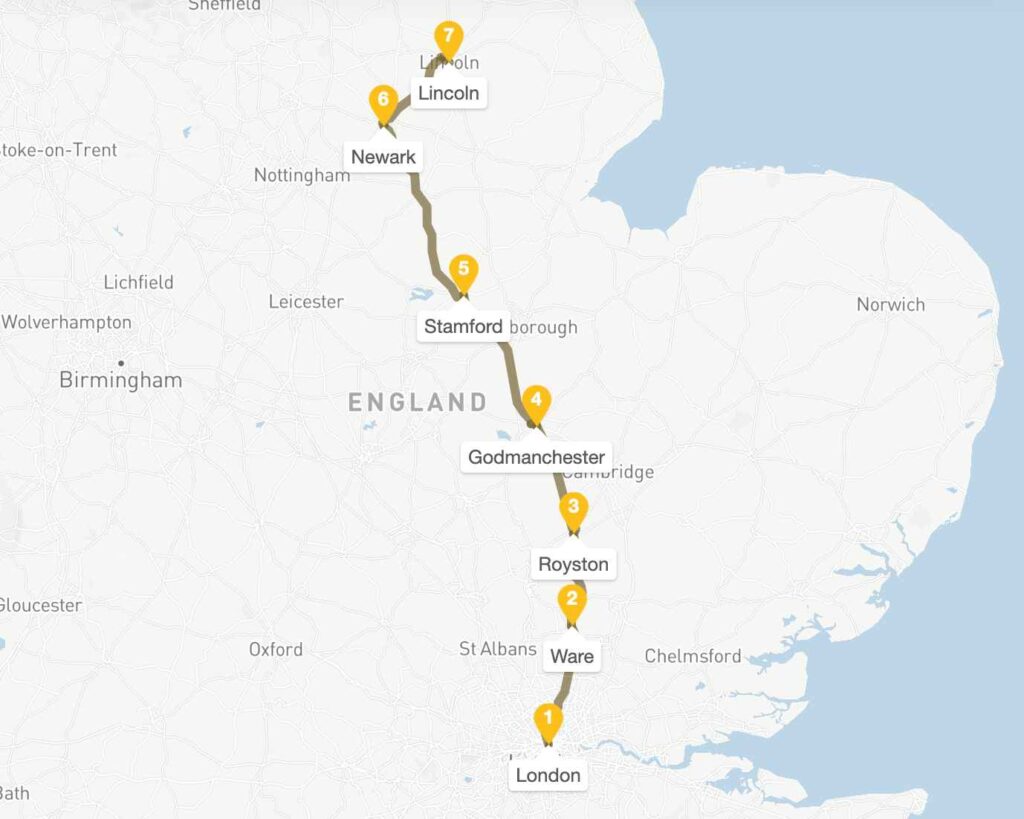
Modern travelers experience the same landscape Roman legions marched through, visiting preserved road sections near Stamford and Ware, exploring Roman towns like Godmanchester and Lincoln.
6. Via Appia Antica (The Appian Way)
The Appian Way was begun in 312 BCE by the censor Appius Claudius Caecus and became the first and most famous of Rome’s great roads. Originally constructed to facilitate military campaigns in southern Italy, it evolved into a crucial commercial artery connecting Rome to the strategic port of Brindisi.
The main part of the Appian Way was started and finished in 312 BC. The road began as a leveled dirt road upon which small stones and mortar were laid. Gravel was laid upon this, which was finally topped with tightly fitting, interlocking stones to provide a flat surface.
| Length | 350 miles (563 km) total; 7 miles accessible from Rome |
| Construction | Started 312 BCE by Censor Appius Claudius Caecus |
| Original Route | Rome to Brindisi (ancient Brundisium) |
| Best Preserved Section | Via Appia Antica from Rome to Castel Gandolfo |
| UNESCO Status | Part of larger Roman archaeological landscape |
The road witnessed some of history’s most dramatic moments, including the crucifixion of 6,000 followers of Spartacus along its length in 71 BCE. Early Christians used it to flee persecution, and it became lined with elaborate tombs and monuments of wealthy Roman families.
Via Appia Antica Itinerary
The route begins at Porta San Sebastiano in Rome and extends southeast through the Alban Hills. The old Appian Way, close to Rome, is now a free tourist attraction.
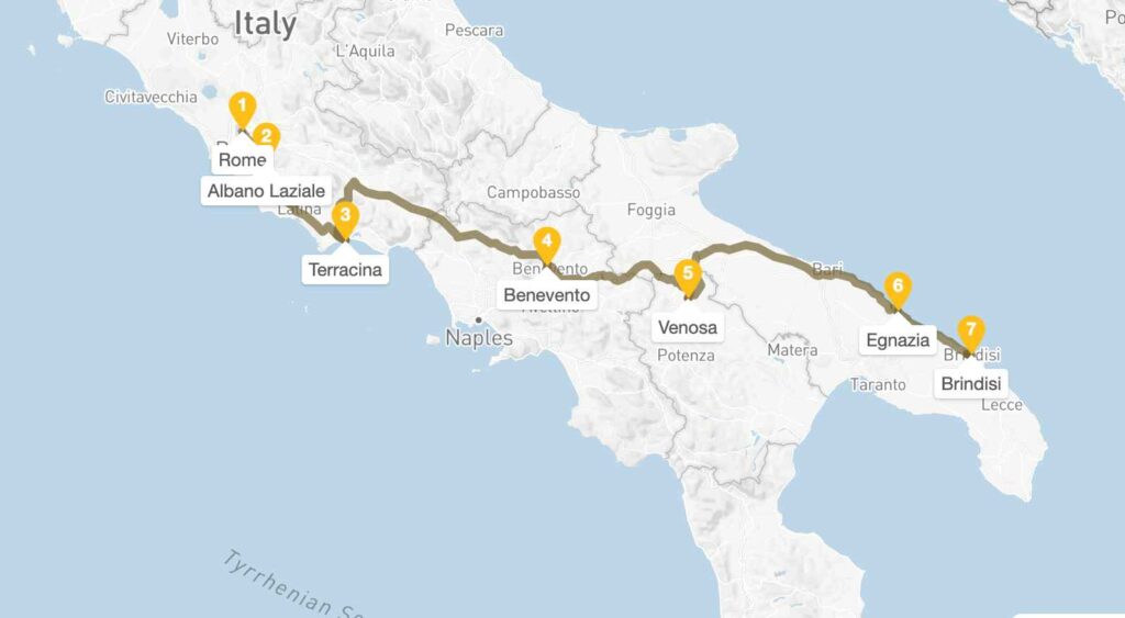
It was extensively restored for Rome’s Millennium and Great Jubilee celebrations. Along the route, you can visit the Catacombs of San Callisto and the Circus of Maxentius
7. Hadrian’s Wall Path
Emperor Hadrian ordered the wall to be built in AD 122, to form a fixed border dividing the Roman Empire from the unconquered Caledonia (Scotland) to the north. Unlike roads built for movement, this stone barrier was designed to control and defend.
- Length: 84 miles (135 km) coast-to-coast
- Construction: AD 122 under Emperor Hadrian
- Original Route: Wallsend (Tyne & Wear) to Bowness-on-Solway (Cumbria)
- Best Preserved Section: Steel Rigg to Housesteads (central section)
- UNESCO Status: “Frontiers of the Roman Empire” World Heritage Site
The wall stood 20 feet high with fortlets every Roman mile, supported by major forts housing auxiliary troops from across the Empire. For nearly 300 years, soldiers from Germany, Spain, and the Balkans manned this remote frontier, creating a unique multicultural military society.
The wall’s abandonment around AD 410 marked the end of Roman Britain, but its massive stones were quarried for centuries to build local farms, churches, and field boundaries throughout Northumberland.
Hadrian’s Wall Path Itinerary
The path runs for 84 miles (135 km), from Wallsend on the east coast of England to Bowness-on-Solway on the west coast. It can easily be done on foot or by bicycle in under 1 week. It’s like the last stages of the Camino, but in the English countryside.
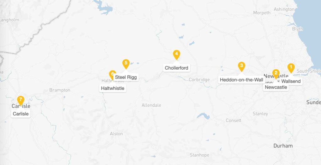
The section from Chollerford to Birdoswald (most of which sits within Northumberland National Park) is often considered the highlight of the walk.
8. Via Francigena: Italy, France, Switzerland, England
The route traces the path taken by Sigeric the Serious, the Archbishop of Canterbury, who made this pilgrimage to Rome in the 10th century and documented his journey in a diary.
- Total Length: 1,900 km (1,180 miles) Canterbury to Rome
- Italian Section: 600 km from Great St. Bernard Pass to Rome
- Historical Origin: Documented by Archbishop Sigeric the Serious, AD 990
- Best Tourist Section: Tuscany: Lucca to Siena (160 km)
- Council of Europe Status: Certified Cultural Route since 1994
Unlike Roman military roads built for conquest, the Via Francigena evolved organically as Europe’s primary north-south artery during the Middle Ages. Frankish kings, German emperors, and countless pilgrims followed this route to reach the tombs of Saints Peter and Paul in Rome.
The Canterbury-to-Rome Pilgrim Highway
The path connected Canterbury Cathedral to the Lateran Basilica in Rome, passing through 79 documented stopping points (mansiones) recorded in Sigeric’s manuscript. Medieval travelers could expect a 79-day journey on foot, with the route serving merchants, diplomats, and religious pilgrims for over five centuries.
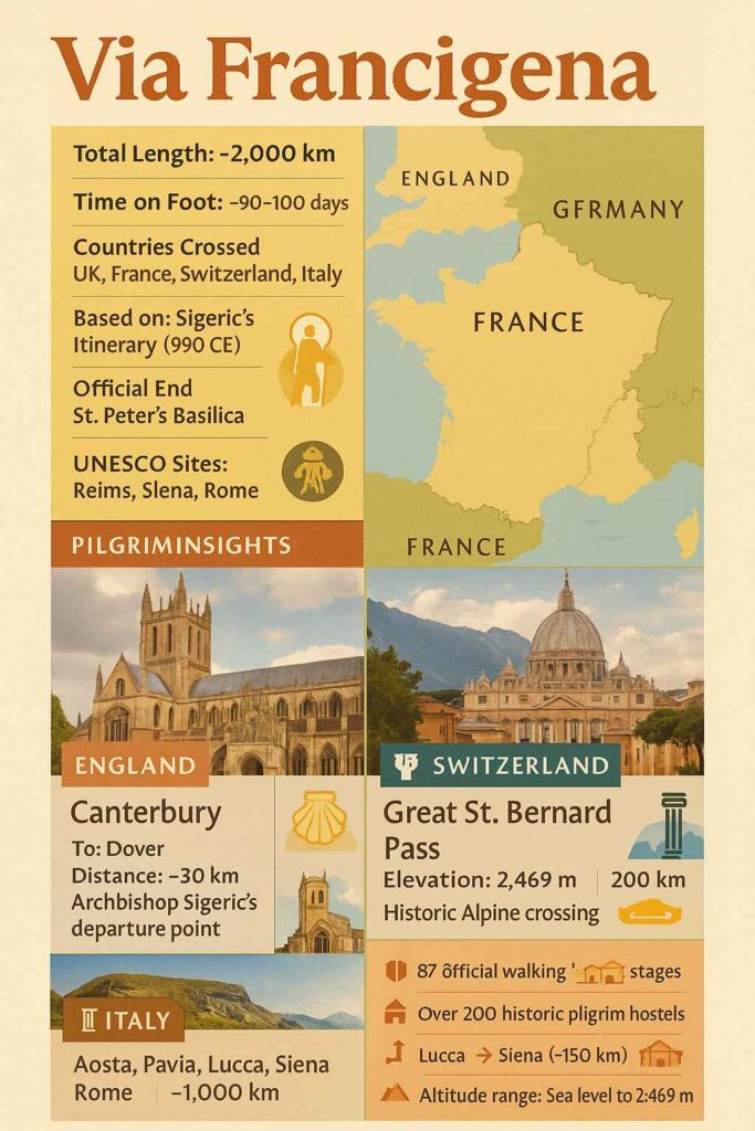
Starting on the legendary white roads of Siena, the route traverses the iconic landscapes of Val d’Arbia and Val d’Orcia, stopping at gems like Bagno Vignoni and Radicofani. The Via Francigena in Tuscany, from Lucca to Siena, is one of the most popular and spectacular stretches of the Via Francigena to Rome.
9. Via Domitia, France: Gateway to Gaul
The Via Domitia was the first Roman road built in Gaul, constructed in 118 BC by the proconsul, Gnaeus Domitius Ahenobarbus, whose name it bore. Unlike other Roman roads built on virgin territory, the route that the Romans regularised and paved was ancient when they set out to survey it, so old that it traces the mythic route travelled by Heracles. Hannibal traversed it on his way from Hispania to Italy, establishing its strategic importance centuries before Roman conquest.
- Total Length: 600 km Pyrenees to Alps
- Construction: 118 BCE by Gnaeus Domitius Ahenobarbus
- Original Route: Col de Montgenèvre → Durance Valley → Nîmes → Narbonne → Pyrenees
- Modern Parallel: A9 Autoroute follows ancient alignment
- Strategic Purpose: Connect Italy with Hispania through Gallia Narbonensis
The land for the route was provided by Massilia in exchange for Rome’s protection, creating the first formal alliance between Rome and a Gallic city.
Via Domitia Route
The road became the economic backbone of Gallia Narbonensis, carrying Spanish silver, Gallic wine, and Italian manufactured goods across the Mediterranean trade network.
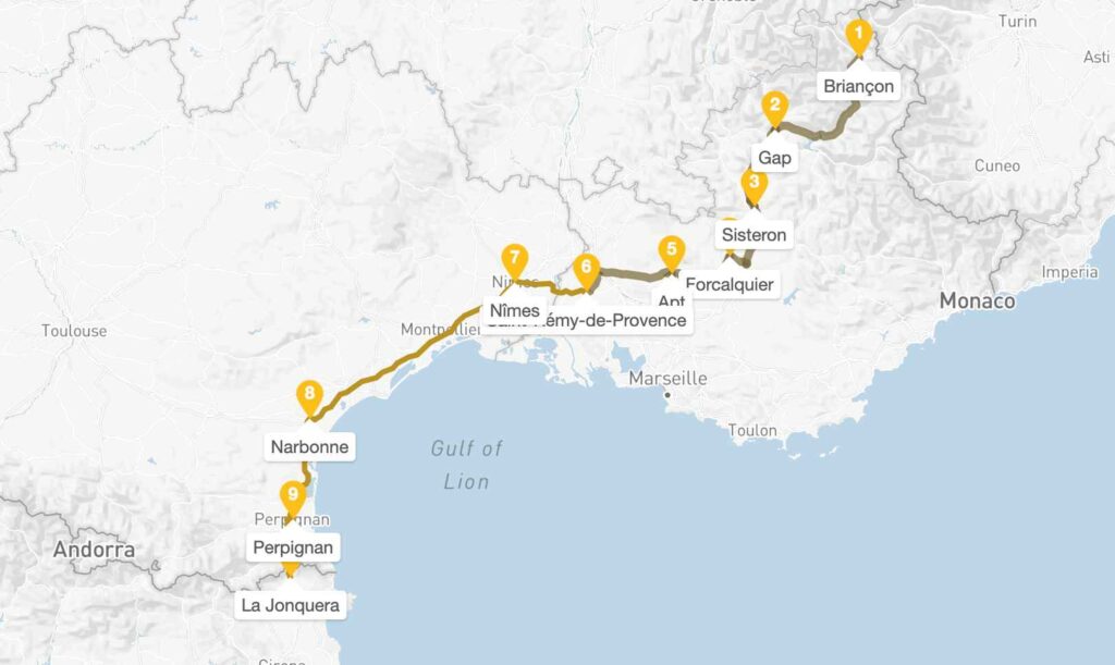
Crossing the Alps by the easiest passage, the Col de Montgenèvre (1850 m), the Via Domitia followed the valley of the Durance, crossed the Rhône at Beaucaire, passed through Nîmes (Nemausus), then followed the coastal plain along the Gulf of Lyon. The most accessible and spectacular preserved sections run between Nîmes and Narbonne.
10. Via Salaria, Italy: The Salt Road
The Via Salaria owes its name to the Latin word for “salt”, since it was the route by which the Sabines living nearer the Tyrrhenian Sea came to fetch salt from the coastal salt pans near the Adriatic. Unlike other Roman roads built primarily for military conquest, the Salaria existed as a trade route before Roman expansion, evolving from ancient Sabine paths used to transport this precious “white gold” that preserved food and sustained armies.
- Length: 242 km, Rome to Porto d’Ascoli (Adriatic coast)
- Construction: Pre-Roman origin, formalized by the Romans 4th century BCE
- Original Route: Porta Salaria (Rome) → Reate (Rieti) → Asculum (Ascoli Piceno)
- Modern Designation: Strada Statale 4 (SS4) follows ancient path
- Economic Purpose: Salt transport from the Adriatic coast to inland Rome
The road’s strategic importance grew when Rome conquered the Sabine territories in the 3rd century BCE. Salt was so valuable that Roman soldiers were sometimes paid in salt – the origin of the word “salary.”
Rome’s Ancient Commodity Highway
The Via Salaria became Rome’s economic lifeline, carrying not just salt but also goods from the Adriatic ports, connecting Rome to the lucrative trade networks of the eastern Mediterranean.
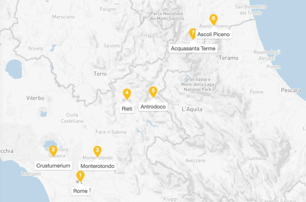
The ancient Roman salt road runs from the capital to the Adriatic Sea, and is still in use today, and is better known as the SS 4 road. It is, in fact, the road between Rome and Rieti. The most accessible and historically significant section for tourists runs from Rome’s Villa Ada to the Sabine Hills around Rieti.
11. Watling Street, England: London to North Wales
Watling Street was one of Britain’s most important Roman arterial roads, constructed soon after the Roman invasion of Britain in A.D. 43. Unlike many Roman roads that followed entirely new routes, Watling Street incorporated ancient Celtic trading paths that had been used for centuries before Roman conquest.
- Total Length: 500 Roman miles (approx. 460 modern miles/740 km) from Richborough to Hadrian’s Wall
- Construction: AD 43-50 by Roman military engineers following the conquest
- Original Route: Dover (Dubris) → Canterbury → London (Londinium) → St. Albans (Verulamium) → Wroxeter (Viroconium)
- Modern Parallel: The A2 road (Dover-London) and A5 road (London-Wroxeter) follow the ancient alignment
- Strategic Purpose: Connect Channel ports with the Welsh frontier and northern garrisons
The road’s strategic importance lay in its role as Britain’s primary military and administrative artery, enabling rapid deployment of troops from the Channel coast to the volatile Welsh borderlands and northern frontiers.
Watling Street Route
It facilitated the movement of Roman legions, government officials, and commercial traffic, becoming the economic backbone that connected Continental Europe with Britain’s mineral wealth and agricultural production.
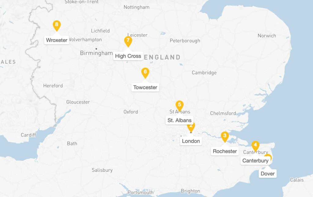
Beginning at the Roman port of Richborough (later Dover), Watling Street crossed the Kentish downs to Canterbury, then continued northwest through the Thames valley to London. From the provincial capital, it struck northwest through St. Albans, traversed the Chiltern Hills, and crossed the Midlands to reach Wroxeter near the Welsh border.
12. Via Egnatia, Greece and Turkey: Eastern Empire Highway
Via Egnatia was the great Roman highway that connected the eastern and western parts of the Roman Empire, begun in 146 BC and completed in 120 BC by the proconsul Gnaeus Egnatius, whose name it bore. Initially following the traces of an older, pre-Roman road running from the Adriatic to the Aegean, the route incorporated ancient trading paths that had linked east and west for centuries before Roman conquest.
The termini of the Via Egnatia and the Via Appia, leading from Rome itself, were almost directly opposite each other on the east and west shores of the Adriatic Sea, establishing its strategic importance as Rome’s primary eastern arterial road.
- Total Length: 1,120 kilometers from Adriatic to Byzantium
- Construction: 146-120 BC by Gnaeus Egnatius, proconsul of Macedonia
- Original Route: Dyrrhachium (Durrës) → Apollonia → Thessalonica → Amphipolis → Byzantium
- Modern Parallel: Egnatia Motorway (A2) follows portions of ancient alignment through Greece
- Strategic Purpose: Link Roman colonies from the Adriatic Sea to the Bosphorus
The route gave the colonies of the southern Balkans a direct connection to Rome and was a vital link to Roman territories further to the east.
Via Egnatia Route
The road became the economic backbone of the eastern Mediterranean, facilitating the movement of troops, officials, and merchants between Rome and its eastern provinces, carrying goods from the Black Sea region to Italian markets.
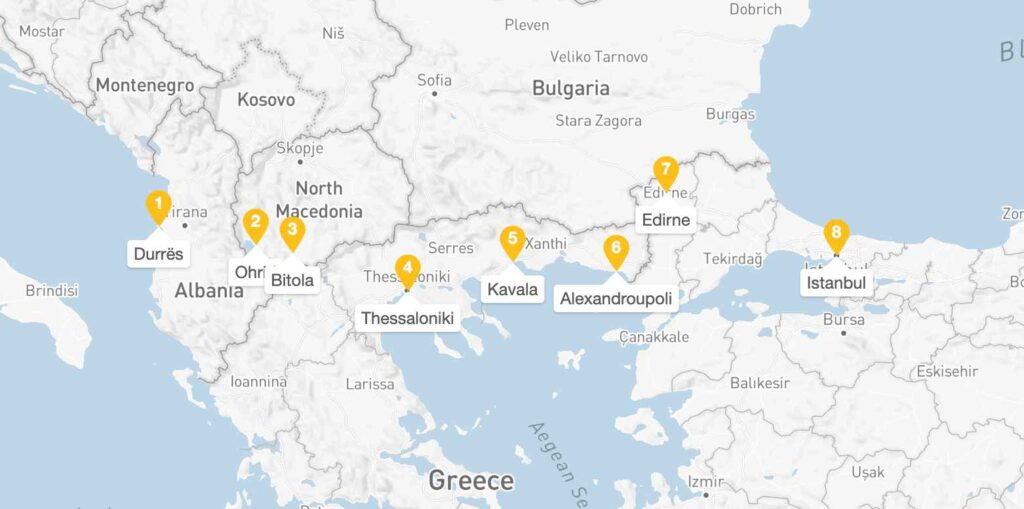
Beginning at the Adriatic ports of Dyrrhachium and Apollonia, two branches of the road united in the Skumbi valley, then crossed the Pindus Mountains into Macedonia. The road passed through Thessalonica, continued east through Amphipolis, crossed into Thrace, and terminated at Byzantium on the Bosphorus.
Choosing Your Roman Road Route
As you have seen, the traces of Roman roads can be seen anywhere throughout Europe, and pretty much in every country you could choose a Roman road route for your trip, be it a rental car or public transportation, and even cycling or walking.
| First-Time | Fosse Way (Bath to Cirencester section) | Easy walking, excellent preservation, English countryside |
| Via Julia Augusta (Nice to Menton) | Spectacular scenery, manageable distance, luxury options | |
| Cycling | Via Claudia Augusta | Purpose-built cycling infrastructure, Alpine challenge |
| Via Augusta (Catalonia section) | Mediterranean climate, cultural highlights | |
| History Buffs | Via Appia | Multiple Roman sites, 2,000 years of continuous use |
| Via Augusta (full route) | Longest Roman road, diverse Spanish regions |
Pin this for later